Climate outlooks
-

The first few days of November have been more than nine degrees below average for most of the Southeast. You can visualize this data for yourself (sample current map shown below) at the High Plains Climate Center’s current climate summary maps website: https://www.hprcc.unl.edu/maps/current/index.php?action=update_region®ion=US Unfortunately for those who like warm weather, these cold conditions are expected to…
-

An article yesterday in The Week shows that bad weather is good for incumbents on Election Day. This may be due to the strong desire of invested citizens to participate in governmental choice compared to what you might call “fair weather” voters who are more likely to be discouraged from voting if the weather is…
-

The state was split into “haves” and “have nots” in October as precipitation was plentiful in western Georgia but sorely lacking in the east. Temperatures across the state were generally above normal and many record highs were broken or tied. In Atlanta, the monthly average temperature was 66.2 degrees F (2.9 degrees above normal), in…
-
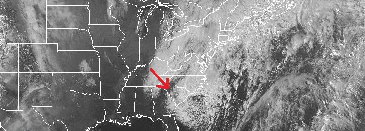
Last night parts of the Southeast experienced their first snowfalls of the year. A few areas in Georgia received over an inch, such as Fannin County, and many people sent in photos to the National Weather Service showing the snow that fell at their locations. Some areas in South Carolina received over 6 inches of…
-
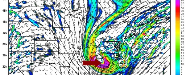
Many weather forecasters on my social media feeds have been highlighting the unusually cold weather that is predicted by many weather models to hit the Southeast this weekend. I have previous written about frost on Saturday and Sunday mornings and the possibility of a few snow flurries in far northeast Georgia. The Capital Weather Gang…
Posted in: Climate outlooks -

The first of two cold fronts will pass through the Southeast on Wednesday, bringing a few showers to the area. A second cold front is expected to come through on Friday, bringing even colder temperatures this weekend. Temperatures below freezing are predicted for large portions of northern Georgia on Saturday and Sunday mornings, with high…
Posted in: Climate outlooks -

The 7-day QPF map shows that most of the Southeast is expected to get less than a quarter inch of rain in the next week. Most of that will fall during a cold front passage Tuesday night to Thursday afternoon. Other than the scattered showers associated with the front, conditions should be mostly dry. Ahead…
Posted in: Climate outlooks