-
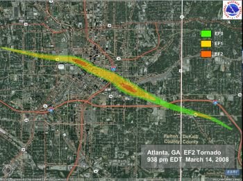
Today is the anniversary of the tornado that hit Atlanta, Georgia, on March 14, 2008. It made a big impression on me because it is one of the few tornadoes I have seen directly impacting my area (I don’t storm chase, I let the tornadoes come to me). My husband (also a meteorologist), son and…
-

Some of you who are older might remember the “Storm of the Century”, which happened on March 12-14, 1993. My in-laws in Birmingham got hit with almost 18 inches of snow and lost power for a week, spending most of that time in bed just to keep warm. My husband (also a meteorologist) and I…
-

When you fly on a commercial flight, you might notice some bumpiness in the air as you go along your route. This is called turbulence, and it can range from very mild to severe. While it’s sometimes uncomfortable, it is very seldom deadly. The best thing to do is to keep your seat belt buckled,…
-

Greenville Online reported this week that South Carolina’s peach crop could be the strongest in years, according to experts from Clemson. Even though they had less chill hours than usual this year due to the warm December across the eastern US, they still got enough to help develop a good crop. South Carolina produces the…
-
In the Southeast you’ve enjoyed a wonderful warm, sunny and dry week here. But to our west, our neighbors in east Texas, Louisiana, Arkansas and Mississippi have been inundated with heavy rain which is locked in place by the combination of a cut-off low pressure area to their southwest and a strong high pressure area…
-
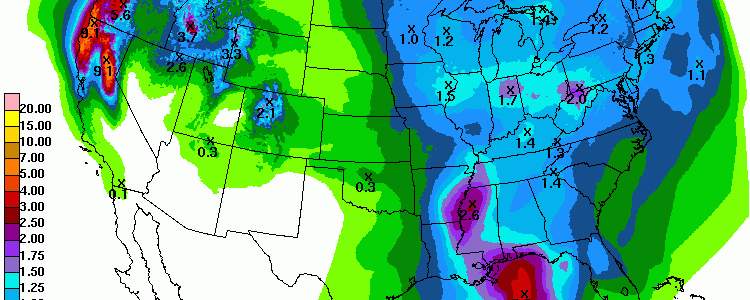
The 7-day QPF shows that the western portion of the Southeast should get the most rain in the next week. This will occur in two batches. The first event is a continuation of the rainy conditions that have plagued Louisiana, Arkansas and Mississippi this week in association with a cut-off low that is moving very…
Posted in: Climate outlooks -
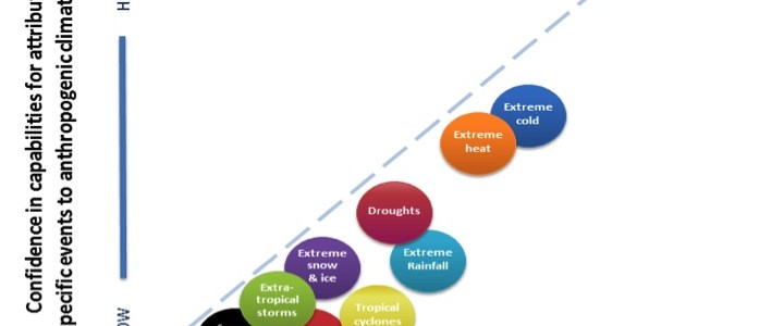
I often get asked if this or that weather event was caused by climate change. In many cases it is impossible to answer the question directly because it depends on a lot of factors. Dr. Marshall Shepherd discusses this question in his latest blog post at Forbes.com here. Some events are easier to attribute to…