-
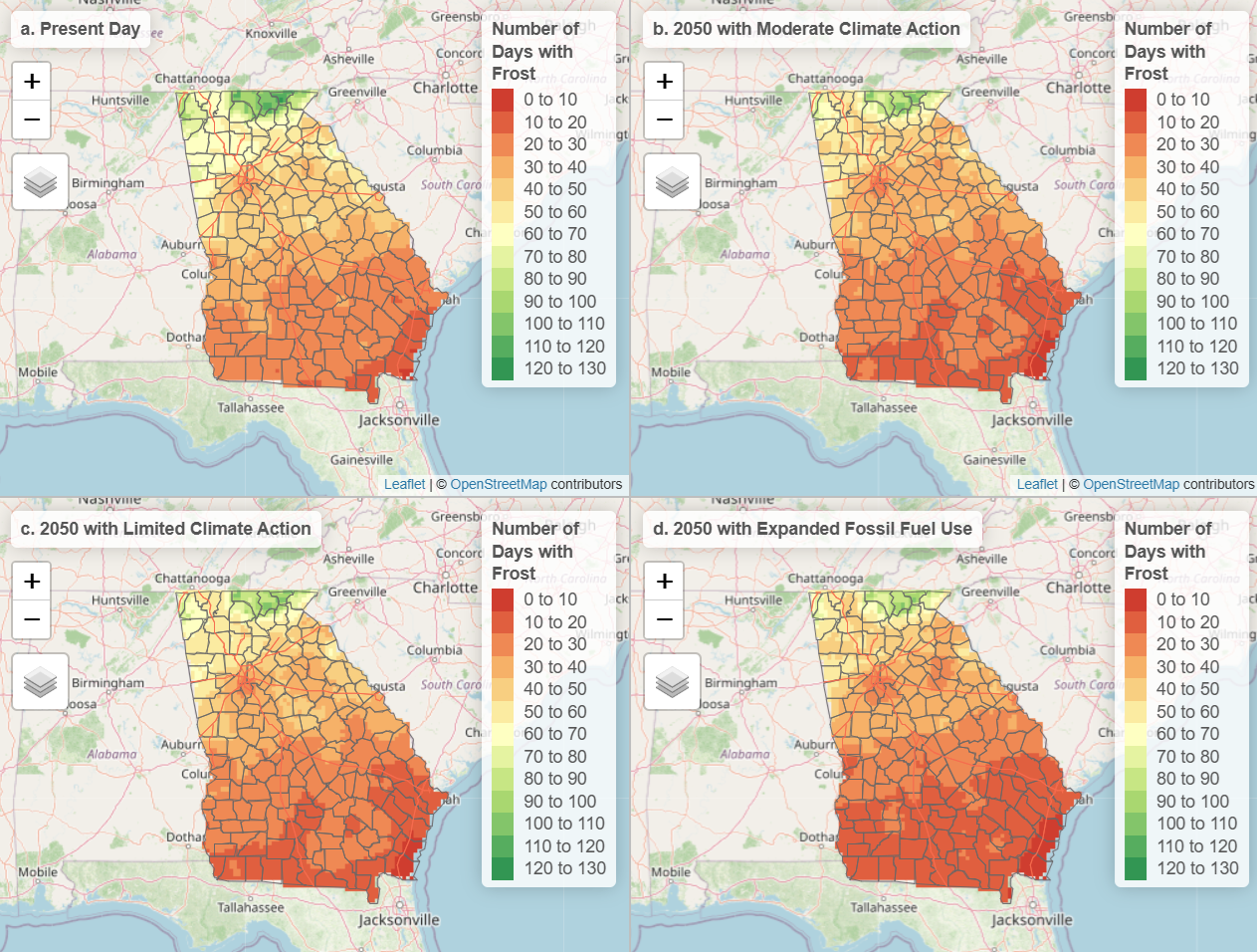
As more greenhouse gases are added to the atmosphere, Georgia’s climate is getting warmer and the rainfall patterns are changing. Future changes depend on actions that we take to curb the emissions. Drawdown Georgia has prepared a set of Georgia-specific climate projections for heat and rainfall trends through 2025 that look at how different decisions…
-
Those of you who follow ENSO know that we are currently transitioning from La Nina to neutral conditions. A strong El Nino is expected to follow by later this summer and last through next winter, although since it is spring there is still a lot of uncertainty in that forecast. If it does happen, what…
Posted in: El Nino and La Nina -

Earlier this week, NOAA released their official spring outlook for climate conditions across the country. It shows that drought is expected to expand in the western US as well as parts of the Plains over the next three months. Fortunately for us in the Southeast, their forecast shows a good chance of improving conditions over…
Posted in: Climate outlooks -

The latest 7-day QPF map shows that there will not be a lot of rain this week in most of the region. On Wednesday a coastal low will bring some rain to parts of eastern Georgia and South Carolina, but most of the rain will occur offshore. Rain will also occur in the Ohio River…
Posted in: Climate outlooks -

This week’s Drought Monitor shows an area of exceptional drought (D4) was added to south-central Georgia and northern Florida this week as conditions continue to be very warm and dry in that region. Drought did improve in Alabama, northern Georgia and North Carolina, but also got worse in western Virginia. In Alabama, dry conditions were…
Posted in: Drought -
A strong and quick-moving cold front will be moving through the region Sunday night through Monday night, bringing the chance of severe weather ahead of the front and along the line of storms. There is some indication in the models that severe weather could occur well out ahead of the front in places like NE…
-

The 7-day QPF map shows that most of the region will see only moderate amounts of rain, and looking at the daily breakdown shows that almost all of it will fall by Monday, with dry conditions for the rest of the week as the really cold air moves in. There’s a separate post about the…
Posted in: Climate outlooks