-
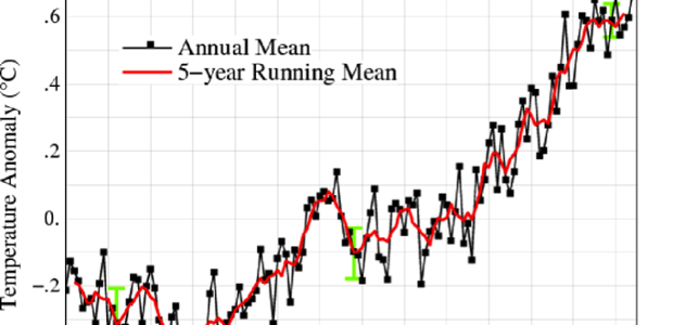
Earlier this week, NASA released its latest estimate for May and year-to-date global temperatures. The latest data show that for 2015 so far, the Earth is on pace to set a new record high temperature. This is due in part to the presence of the large pool of warmer than normal ocean temperatures in the…
Posted in: Climate and Ag in the news -

As of 10 pm, the National Hurricane Center has declared there is enough of a circulation in the Gulf of Mexico to declare it a tropical storm named Bill. As predicted, Bill is headed for Texas where the ground is already sodden from persistent rain in the last few weeks. This means that flooding is highly…
-
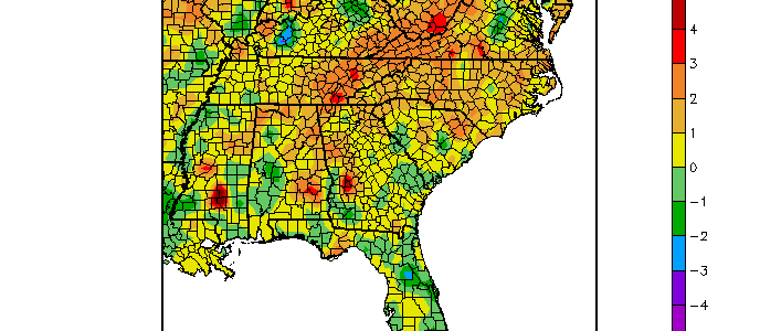
Since it is halfway through June, let’s take a look at how the region is stacking up so far. For the region as a whole, temperatures are running 1-2 degrees above normal and precipitation, 1-2 inches above normal. However, the final average temperature for the month is likely to rise since the current above normal…
-
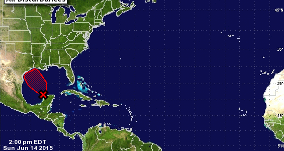
The National Hurricane Center reported today that a tropical disturbance off the Yucatan Peninsula of Mexico is 80 percent likely to become a tropical depression in the next few days. This area, currently called Investigation 91L, is expect to strengthen over the warm Gulf of Mexico and could develop into a tropical depression and perhaps…
-

Areas of the western US are looking for sources of additional water to help ease shortages caused by the continuing 4-year drought. Some scientists wondered if thinning the forests to reduce water use might improve water catches into reservoirs and increase water supply. However, as noted in this blog posting from the Southern Research Center…
-

In this series of blog postings I’ve highlighted some of the different places you can get weather and climate data in the Southeast. Today I highlight FAWN, the Florida Automated Weather Network. FAWN’s home site is https://fawn.ifas.ufl.edu/ at the University of Florida. FAWN is a network of over 40 stations scattered across Florida which collect current…
-

A dome of high pressure is moving into the Southeast this weekend and should stay parked over the area for much of the week. The high pressure will suppress most thunderstorm activity and shunt rain off to the west of our region. Above normal temperatures and high humidities will make it feel occasionally like it is…