Climate outlooks
-

David Zierden, the Florida State Climatologist, posted a new blog entry today on the blog site for the Southeast Innovative Farming Team (SIFT). Here is the link. In the post he discusses the cold weather that we expect for the rest of February and the winter to date. Looks like the groundhog was right–winter is…
-

After some nice warm and sunny days, a blast of winter air will be returning to the Southeast by Thursday and will last for several days. The wind map below shows the push of frigid air into the region from Canada. You can see it in action at https://hint.fm/wind/ or the full global version at https://earth.nullschool.net/.…
-

We’ve been watching the Eastern Pacific Ocean for almost a year, waiting for the onset of El Nino. In the Southeast, El Nino occurrences are related to cool and wet winters and decreased tropical storm activity, so when one occurs we have some extra knowledge about how the weather is likely to behave for the…
-
The outlook for the next two weeks is looking mostly cool and drier than average, although there will be some rain and a few warm days. For the next week, most of the Southeast should see one shot of rain on Monday with totals of less than half an inch, followed by several dry days…
Posted in: Climate outlooks -

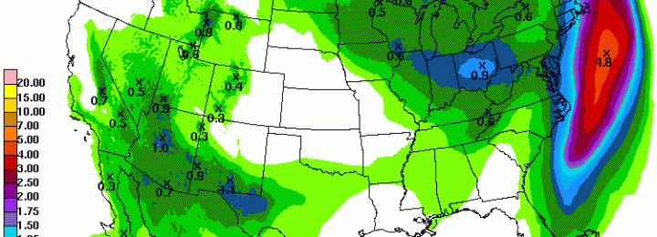
The next round of rain should enter the Southeast late Saturday night into Sunday. Most of the day on Sunday should be fairly wet, depending on where you are, with amounts of 1/2 to 1 inch in most areas. That system will exit the Southeast on Monday as a cold front moves through the region…
Posted in: Climate outlooks -
Now that the latest round of rain has mostly left the Southeast, the week ahead should be fairly dry, especially if you are in southern Georgia. The remnants of the storm are still moving through the coastal areas of North Carolina and rainfall will be enhanced there by the development of an East Coast storm.…
Posted in: Climate outlooks -
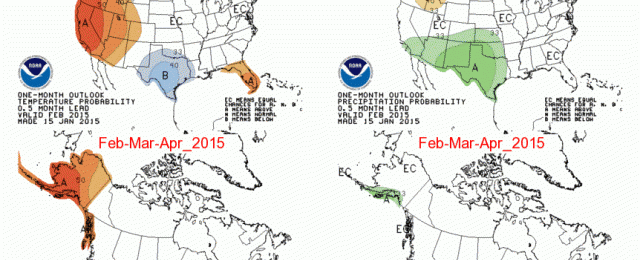
The latest seasonal forecasts were released by the Climate Prediction Center this week and show little indication of what our next three months could be like. With the chances for an El Nino rapidly waning, there is nothing in the atmospheric pattern to suggest whether our temperature and precipitation will be near, above or below…