Colder Temperatures This Week – Pam Knox
The recent warm weather has caused sap to start rising in grapevines in northern GA and early blooming of some plants (perhaps including blueberries) in southern Georgia. However, that warm weather is going away and we will go through another period of normal to below-normal temperature for the next week or two. The average date of the last spring freeze is still 2 weeks to 2 months away except on the Georgia coast, depending where in Georgia you are. The latest frosts can occur well after that. You can find maps of approximate last freeze dates at http://agroclimate.org/tools/freeze-risk-probabilities/. This cold spell could last through the next two weeks before temperatures warm up again. Northern GA will probably see freezing conditions on Monday and Tuesday this week. South Georgia may stay above freezing but even colder weather is expected to occur after that, so the chance of frost is not over.
The most vulnerable crop right now is the blueberry crop. The plants have had plenty of chill hours this year so the warm spell may have started to bring them out of dormancy. If your blueberries are in that condition, then you will need to assess whether to use frost protection methods to protect them. The temperature sensitivity depends on what stage the buds are. You can find more information on the relationship between bud condition and resistance to cold temperatures in the appendix to our publication on Freeze Protection at https://secure.caes.uga.edu/extension/publications/files/pdf/B%201479_2.PDF. Note that this is on a secure UGA server so you may need to download it to send it to your producers if they want it.
If you are going to do freeze protection, then you will need to watch hourly forecasts to determine when to turn on the irrigation system or start other methods. Our website at http://weather.uga.edu/ gives a 12-hour forecast by choosing the station and then Forecast from the left menu. Pick Temperature Forecast and it will give a local forecast for that station. If you want to know what is going to happen several days ahead, then I recommend using the hourly graphical forecasts from the National Weather Service. You can get instructions on how to get it at https://site.extension.uga.edu/climate/2018/03/where-to-get-hourly-weather-forecast-information/. These forecasts can be generated for any location, not just a UGA station, and show the next 6 days of temperature, dew point, wind, and sky cover. Of course they will change over time, so you need to keep checking to see what the latest forecast is.
Why has this La Nina winter been so cold? – Pam Knox
In the week I have received several questions about why this winter, which was predicted to be warmer and drier than usual, has been so cold. Here is a response I wrote to Bob Kemerait, UGA, about this winter’s crazy weather and the lack of warm weather (so far). You might find it helpful too.
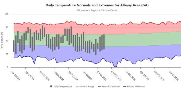
La Nina was not officially declared until earlier in January, so we have been skirting with neutral to weak La Nina conditions for most of the past few months. Neutral years and weak La Ninas both have the capability of having cold outbreaks occur because the circulation around the North Pole is weak and so lobes of the coldest air can push down into the mid-latitudes, and that is what we have been seeing. Since this La Nina is likely to be weak and last for only a few months before we go back to neutral conditions, we may see more of these in the next couple of weeks or months. In spite of the cold outbreaks, though, it has not been as much below normal as you might think. The graph below shows the daily temps compared to normal and extremes (green is normal, red extreme highs, blue extreme lows, gray is this year’s data) for Albany (Tifton had some missing data). We have had cold weather, but in between we have had temperatures that have been warmer than normal. Friday January 17 it got up to 60 F in Athens, which is definitely above normal for mid-January, which is usually just about the coldest week of the year. Albany’s average temperature so far this winter is ranked 37 out of 120 years of data, so while we are colder than average, we are not near a record-setting winter even with the cold outbreaks so far.
While the winter has been colder than normal so far, it has also been drier than usual, as we expect with La Nina, in spite of the storms we have had go through. As far as I am concerned, any precip we get over a La Nina winter is probably a good thing going into the next growing season, since La Nina springs often see early season dry conditions and even drought due to the lack of soil moisture recharge over the winter.
Of course, we also have to keep in mind that predictions for La Nina winters are based on probabilities, and even if 8 out of 10 years follow the expected pattern, that means two years don’t, and maybe it’s just one of those years. Every El Nino and La Nina is different because they are linked to what is happening around the rest of the globe.
If you are interested in reading more, here are a couple of related articles that you might find helpful in understanding what we are seeing this winter:
AgWeb: With More Arctic Air Set to Blast the U.S., Why This Winter Could Be Remembered for Its Extremes
USA Today: Arctic blast about to invade US. What happened to warm winter predictions?