Sources of weather and climate data
-

Now that the grant for “Animal Agriculture in a Changing Climate” is ending, the course materials, including the original video modules and reference material, have been moved to the eXtension site for at least the next year. While the course is no longer offered, all of the materials can still be used for self-study. Many…
-
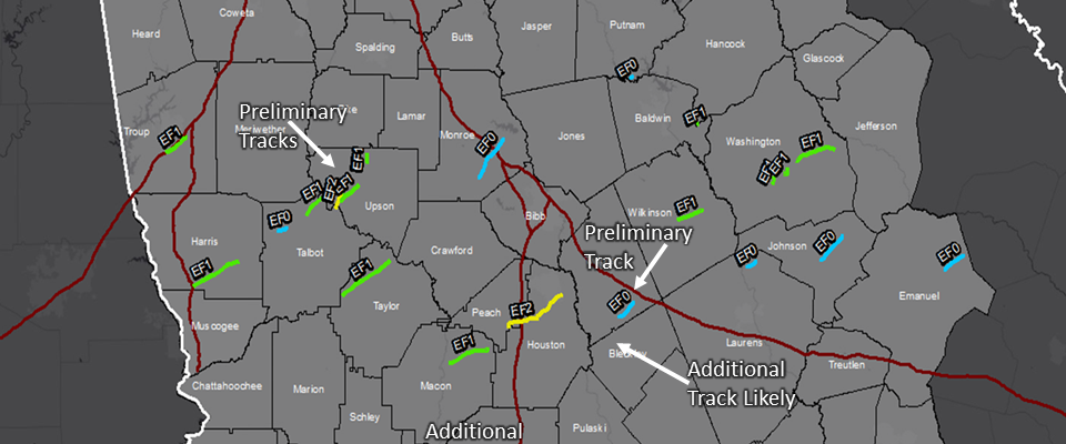
I want to give a shout-out to the National Weather Service employees in the Southeast this week who have been out surveying tornado damage this week following the severe storms we had in several states. The map below shows the tornado tracks that have been identified by NWS employees from just the Peachtree City office…
-

I am not a Twitter user, since I spend too much time on social media already, but if you are and you enjoy weather content, you should check out this list of the best 100 weather- and climate-related feeds on Twitter. You will recognize several of the sites, since I steal from use their Facebook…
-
NOAA’s National Centers for Environmental Information have just released a set of very useful and descriptive state climate summaries that discuss both past climate and projections of future climate. A separate publication is available for each state, and includes graphics for temperature, precipitation, extreme events and sea level (for coastal states). You can read about…
-

In view of the storm that is moving through the Southeast today and this weekend, I thought a refresher on how to measure snow would be helpful. The National Weather Service offices would love it if you provide snow depth reports via Twitter or their web sites. I’ve got my rain gauge ready and my…
-

Here’s a website which lists sources of information on weather and climate in the National Weather Service’s Southern Region. It includes a number of decision support tools, data sets, and other information for areas from New Mexico through Georgia and Florida. You can see it at https://www.ncdc.noaa.gov/rcsd/southern. If you are in the Carolinas, you can replace…
-

The US Forest Service has a useful web site that serves as a resource center for topics on climate change and how it is likely to affect forests and grasslands in years to come. The site includes a number of modules on climate science, impacts of changing climate, and how land managers can respond. You…