Interesting weather images
-

Check out this fantastic shot of the aurora borealis from the Suomi National Polar-Orbiting Partnership. It was taken by the Day/Night Band on the Visible Infrared Imaging Radiometer Suite (VIIRS) instrumentover Canada in the early hours on September 29, 2016. Image Credit: Cooperative Institute for Meteorological Satellite Studies at the University of Wisconsin-Madison
Posted in: Interesting weather images -
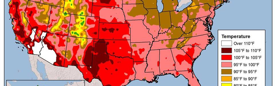
The Western Regional Climate Center provided a map this morning of the maximum temperature (at least so far) for 2016 across the US. Since we’re past the date of most areas’ maximum temperature for the year, this is likely to be close to the map for the entire year. This year, a lot of the…
-

MSN published a slideshow of their picks for top photos of rare weather events this week. You can see the slides here. I see a lot of weather photos on my Facebook feed as well as in other places, and these are definitely some good ones. Enjoy!
Posted in: Interesting weather images -

This Day in Weather History‘s Facebook page showed a photo of Tropical Storm Esther on September 20, 1061 as taken from the TIROS satellite. As far as I can tell, this is the first time that a tropical storm was identified first by satellite. Here’s the text accompanying the image: “September 20th, 1961 – On…
-

Today is a great day to remind folks in the Southeast about these moving wind maps! You can find the black and white US map at https://hint.fm/wind/ and a nice global coverage map at https://earth.nullschool.net/. The global map also allows you to zoom and to look at different layers, but I can’t get the zoom feature…
Posted in: Interesting weather images -
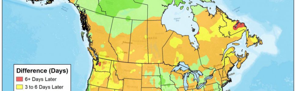
The Weather Channel posted an interesting map earlier this month showing how the date of the peak heat in the summer has changed over time. Parts of the US are peaking later in the summer, but in most of the Southeast, the average date of the highest temperature is actually coming several days earlier now…
-
Forbes magazine had an interesting video this week highlighting the history of viewing Earth from space, starting with rocket-based photography in 1946 and continuing through satellites to human space flight to planetary explorers. My major professor as a Master of Science student was Dr. Vernor Suomi, the “father” of satellite meteorology, who recognized the importance of…