Pam Knox
-

Our sister blog for the “Animal Agriculture in a Changing Climate” project has a new blog post out this week with the title above. You can read the post at https://animalagclimatechange.org/mother-nature-always-wins/. The blog discusses the impacts of extreme weather events on livestock production and agriculture and how future extreme events might impact farmers. The project has a…
-
The cold and dry air moving into the state late this week could lead to scattered frost this weekend in low-lying areas that are prone to experiencing cold air drainage. The NWS in Peachtree City has put out an advisory slide on their home page warning about the possibility Saturday through Monday mornings. Not all…
-

While most people have been focused on the wet conditions in the Carolinas and Virginia which eliminated a lot of drought last week, other areas of the Southeast have been getting drier. Today the National Drought Monitor increased moderate drought in a small area of south-central Georgia and the western counties of Alabama due to…
-
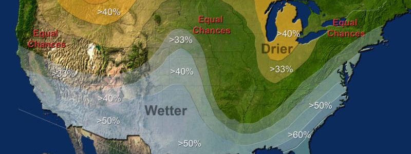
NOAA released their winter outlook today. As expected, it shows the primary impact as the strong El Niño that is currently underway in the eastern Pacific Ocean. Here in the Southeast, we expect the subtropical jet to move over southern parts of the region, causing cloudiness, cooler temperatures and more rain than non-El Niño years.…
-

The month of October so far this year has been very dry and warm across most of the country. The exception: the Southeast, where the heavy rains in South Carolina show up as the only green spot in a sea of red. Other areas in the Southeast have been dry as most of the rainfall…
-

Dr. Jeff Masters’ blog in WeatherUnderground this week discusses what may be the most costly disaster on Earth this year, but one that has escaped notice in most of the United States. Here is what he has to say: “Earth’s most expensive weather-related disaster of 2015–and the most expensive disaster in Indonesia’s history–is underway in…
-

The State Climate Office of North Carolina has been posting a series of articles on extreme weather in North Carolina. The latest offering describes the most extreme hurricane to hit each part of the state along with facts about each storm. You can read it at https://climate.ncsu.edu/climateblog?id=157&h=5666e5c1.