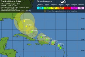
By now many of you are aware of Tropical Storm Erika’s forecasted path. Pam Knox, Extension Climatologist, sent the following info:
“Meteorologists have been watching the development of Tropical Storm Erika in the western Atlantic Ocean. It is located today east of the Lower Antilles and the Virgin Islands. The storm is forecast to gain strength to hurricane status and to move over southern Florida by Monday morning. From there it is expected to move north and could affect the weather in southern Georgia by later in the day on Monday and through mid-week.
Impacts from Erika could include heavy downpours, gusty winds and isolated tornadoes. These can occur in the spiral bands far ahead of the main storm. For example, as hurricane Ivan was making landfall on the Gulf Coast in 2004, a tornado touchdown in a spiral band occurred in Athens far from the coast. Heavy rains could cause localized flooding in low-lying areas, so plan to remove livestock and farm equipment from those areas ahead of the storm. Power outages could also occur if winds blow down tree limbs from drought-weakened trees.”
For farmers, A tropical storm with wind and rain would increase disease risk and also likely delay getting back into the field.
If the storm heads our way, it would likely hit at the beginning of next week. Growers that need to protect crop(s) with fungicides should be prepared to do so asap before the storm arrives. Harvesting in fields should continue on with the understanding that it may be a week before you can get back into the fields after the storm.
For pecan growers, my advice is to start praying now! With some of the crop load I’ve seen, heavy winds would be devastating in orchards.
