-
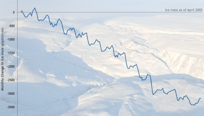
A new NOAA-sponsored report shows that unprecedented warming air temperature in 2016 over the Arctic contributed to a record-breaking delay in the fall sea ice freeze-up, leading to extensive melting of Greenland ice sheet and land-based snow cover. The Arctic Report Card, released this week at the annual American Geophysical Union fall meeting in San Francisco,…
-

According to Nova Next on PBS, scientists at the National Center for Atmospheric Research (NCAR) have analyzed soil moisture and snowpack data in the months leading up to the drought and have discovered that they could have been used to make a much earlier drought prediction. If the model can be applied to similar droughts…
-
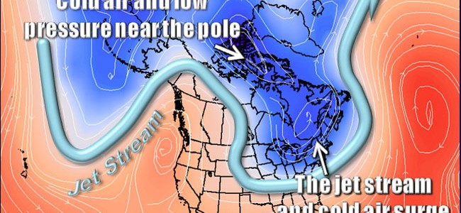
There are a number of concepts in weather and climate that are confusing to the public and even sometimes to scientists in different specialties. Terms like the “polar vortex” are often misused by the media as well, increasing the confusion. Dr. Marshall Shepherd of UGA has written a post for Forbes.com to explain some of…
Posted in: Climate science -

The Southeast Regional Climate Hub has published their latest newsletter today. It highlights the conference I attended and spoke at last week on Weather & Climate Decision Tools for Farmers, Ranchers & Land Managers Conference. You can view it at https://content.govdelivery.com/accounts/USDAOCE/bulletins/17639e8.
Posted in: Climate and Ag in the news -
NOAA has just released a very nice photo retrospective of the 2016 hurricane season in the Atlantic Basin. The season was considered as “above normal” this year because of the number of storms. Be sure to check it out at https://portal.nnvl.noaa.gov/arcgis/apps/MapJournal/index.html?appid=2961a294abf74674a30bd973703c91d3.
-
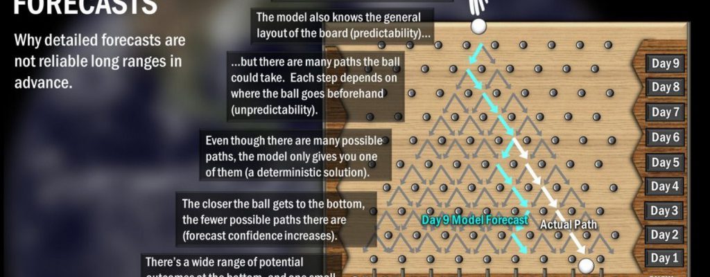
This time of year I start to get questions about what the weather will be like around Christmas because people are traveling to see friends and family or just want to know what conditions will be like where they live. Well, Christmas is still 13 days away, and the weather models just can’t forecast accurately…
-
The Global Surface Water Explorer is a new website/app which allows you to look at changes in surface water over time using archived LANDSAT data. Changes include both lakes shrinking as water is diverted to irrigation and water supply and lakes growing as glaciers melt faster than they can gather new snow. You can read…