-

Here is a story that links events in World War 2 to impacts on tree rings in Norway. According to the story, a German dendrochronologist noted that many trees along the Norwegian coast near Kåfjord. In 1945, the Germans were hiding their battleship the Tirpitz there using chlorosulphuric acid as a sort of “chemical fog” to try…
-

Floods are a liquid disaster caused by heavy precipitation or training storms which drop their moisture over the same spot over and over again. Slow-moving storms and saturated soils can contribute to the volume of water that comes down the river channels. In some parts of the country, rain falling on snow makes rapid snowmelt…
-
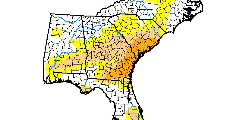
This week’s Drought Monitor shows a slight decrease in drought conditions in northwest Alabama and in North Carolina as well as a reduction in abnormally dry conditions in Florida. Drought slightly expanded in Georgia, South Carolina and Virginia due to lack of rainfall in those areas. Most of the Southeast should get rain this week,…
Posted in: Drought -

Changes in how land is used can affect the local climate in a number of ways. The addition of irrigation can add moisture to the region, increasing the likelihood of summer rain and cooling temperatures. Changing the land surface by adding cover crops can also affect the climate by changing the way rainfall is absorbed…
Posted in: Climate and Ag in the news -

Today is the highest amount of pollen so far this year according to news reports from Atlanta, and I can believe it from how my sinuses are behaving. But where do you get pollen counts? Here is one source from the American Academy of Allergy Asthma and Immunology that looks to be useful. It provides…
-

Yesterday my neighbor pointed out that one of the pines in my yard was dead. Another one nearby looks sick, so I need to have them checked for southern pine beetles. So this article on the spread of southern pine beetles into the Northeast was especially timely. Even though this winter in New England has…
-
Some recently published research by a group of Florida State University scientists has shown that while total rainfall across Florida has remained constant, urban areas are receiving that rain in shorter, more intense bursts than areas that are rural in nature. Their research links this to changes in land use and land cover in the…