Interesting weather images
-
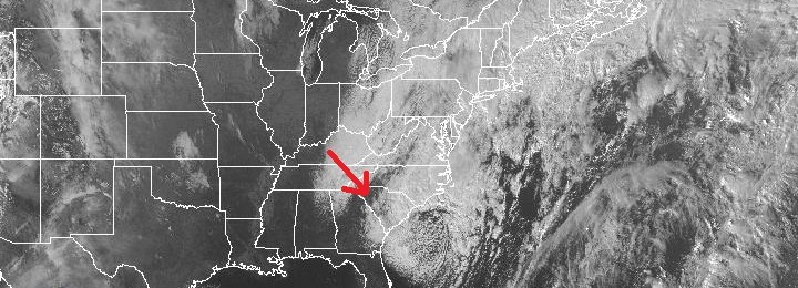
Last night parts of the Southeast experienced their first snowfalls of the year. A few areas in Georgia received over an inch, such as Fannin County, and many people sent in photos to the National Weather Service showing the snow that fell at their locations. Some areas in South Carolina received over 6 inches of…
-
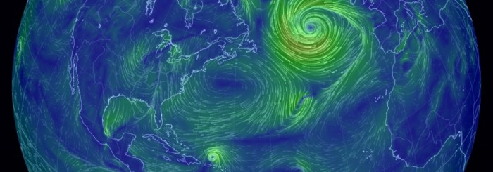
Even though the storm system hitting the eastern US today is pretty strong, it pales in comparison to the massive low pressure center south of Iceland in the northeast Atlantic Ocean today. For a great picture of the streamlines of wind across the North Atlantic, go to https://earth.nullschool.net/#current/wind/surface/level/orthographic=-56.44,38.74,563 and watch the wind in motion. I’ve…
-

This surface temperature map and weather analysis shows the changes that are coming to the Southeast as the next cold front passes. On this map from Chris Robbin’s Facebook page, you can see the cold air behind the advancing cold front, which is just to the west of Mississippi. The remains of the cold…
Posted in: Interesting weather images -
NASA sends out a picture of the day on email every day. and today was a beautiful one. Seeing the fall colors from space makes fall feel more real. Here is the caption that goes with the image below: A few days after autumn showed up on the calendar in the Northern Hemisphere, it showed…
Posted in: Interesting weather images -
In a previous post I discussed the “wedge,” a weather phenomenon that brings cool air down the east side of the Appalachian Mountains into the Southeast. Officially, it is called a cold air damming event, since the mountains prevent the movement of cool dense air into the mountains but direct it along the eastern slopes. …
Posted in: Interesting weather images -
As a meteorologist I am always fascinated by time-lapse videos of clouds moving. They really show that the atmosphere is a fluid not much different than water. This week I ran across two beautiful examples that really capture this. The first one is a video of a sky covered by a cloud type called Undulatus…
Posted in: Interesting weather images -
The evaporative stress index is a way of measuring rates of evapotranspiration from plants and the ground using satellite data. The higher the rates of water use, the more negative the evaporative stress index. The two maps below show the maps for September 2 and September 8. You can see that on September 2,…