Interesting weather images
-

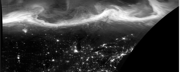
Fall color is on the way! I saw an incredible MODIS satellite picture of fall color in the upper peninsula of Michigan and northern Wisconsin yesterday and wanted to share it with you. The photo is below but to really get the best high resolution look at it, click here.
Posted in: Interesting weather images -

NASA released a photo from the Terra satellite showing the evidence of the South Carolina flooding as seen from space. Here it is, as annotated by the NWS Wilmington NC office.
-

The streamflow image from https://earth.nullschool.net this morning shows the complicated pattern that is affecting the weather in the Southeast today. The first image shows the surface wind across the Southeast, which includes the spin of Hurricane Joaquin, plus the weaker spin of Investigation 90 to the east, which has an 80 percent chance of becoming a named…
-

The 11 pm forecast track for Hurricane Joaquin shows the tendency toward moving the track east is continuing, with the latest track now holding the center of the storm well off the East Coast as it travels north. This will result in less hurricane-based impacts from the storm in the Southeast. The 10:30 pm infrared NOAA…
-

The Facebook feed for “This Day in Weather History” reminded me that in 1999, Hurricane Floyd was approaching the Southeast with winds of 145 mph. It did not hit the coast but veered north, paralleling the coast and causing massive evacuations and traffic problems. Some of the current policies in place for using interstate highways…
-
Did you know that the vast majority of weather data that goes into weather forecast models comes not from ground measurements, but from satellite observations? This increase in global data, plus the increased power of computers, has improved weather forecasting dramatically over time. It’s hard to believe that satellite meteorology only started in the 1960’s,…
-
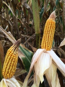
AgWeb posted a short article this week based on a poster from Ohio State University on common problems with ears of corn. The article showed pictures of different kinds of abnormalities and linked them to potential causes of each condition. Many of them are related to adverse climate effects like cold temperatures or drought happening at…