Climate outlooks
-
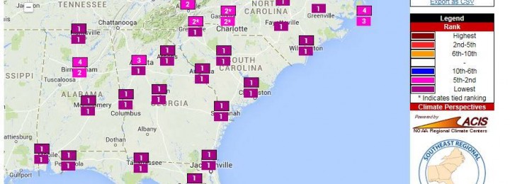
My meteorologist and climatologist friends have been posting one story after another about the extreme cold weather we have experienced in the past day. Today many areas set records for low maximum temperature, and some record lows were set. Tomorrow morning, many more record lows are expected to be broken. The Southeast Regional Climate Center…
-

The cool conditions continue for at least the next week. Rain is expected to move into the area on Sunday night and last through Monday, bringing up to 1.5 inches to some areas. After that, even colder air moves into the state, with the possibility of breaking record low maximum temperatures on Tuesday and low…
Posted in: Climate outlooks -

One of the toughest things for climatologists to explain is what a 55 percent chance of El Nino or a 40 percent chance of an above normal winter is. Two examples of probabilistic forecasts are shown below. The pie chart is from AgroClimate.org and the bar graph is from IRI at Columbia University. Most people think…
-
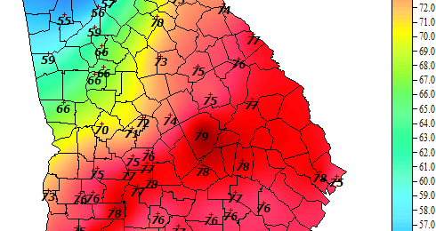
Here is the 4 pm temperature map from the Georgia Automated Environmental Monitoring Network: And here is the surface analysis at the same time: Can you find the front on the temperature map? Cold fronts mark the boundary between warm air in place and the cold air that is advancing into the warm air. In…
-
In the past few weeks there have been many forecasts for the coming winter made online. Most are from bloggers with limited meteorological or climatological training, and should be taken with a large grain of salt. Others, from places like the Farmers’ Almanac, are mysteriously produced and vaguely worded so that they can claim they…
-

There has been a tremendous amount of hype the last few days about the coming cold outbreak that will be affecting most of the eastern 2/3 of the United States. Some bloggers and pundits have talked about “bombogenesis” and the return of the “polar vortex” and unprecedented cold temperatures. Dr. Michio Kaku, the so-called “science…
-

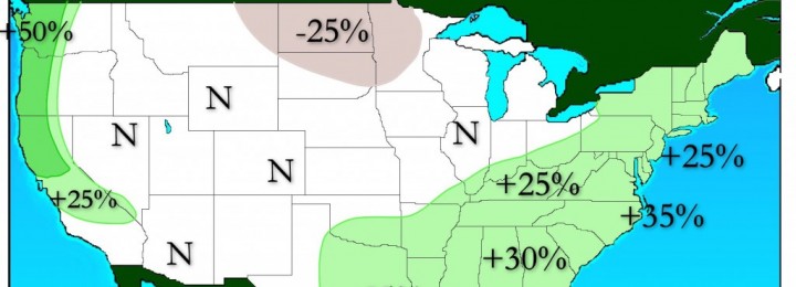
The 7-day QPF map shows another dry week in store for most of the Southeast. The only exception will be the peninsula of Florida, which will see a lot of rain along the boundary of the unusually cold air that is expected to move into the area during the week. I’ve discussed this outbreak of…
Posted in: Climate outlooks