Climate outlooks
-

NOAA’s latest El Niño update shows that El Niño is still present in the eastern Pacific Ocean, although its strength has waned somewhat. The latest set of prediction graphs from IRI show that it is expected to continue for most of the next year, with only a few models suggesting a swing to La Niña.…
-
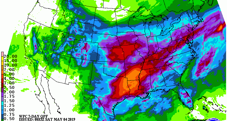
The latest 7-day QPF map for the US shows that most of the rain that is expected to fall in the Southeast this week will fall before Tuesday morning as a strong system moves through the area. There is some potential for severe weather on Saturday. After the weekend, the focus of rain activity shifts…
Posted in: Climate outlooks -

The latest outlook for May 2019 shows that the entire Southeast has a high probability of being above normal in temperature, with a percentage of more than 50% chance of above normal, 33 % chance of near normal, and just 16 % chance of cooler than normal temperatures for the month. Precipitation along the East…
Posted in: Climate outlooks -
Strong high pressure is expected to dominate the weather in the Southeast this coming week. No rain at all is expected until late in the week, and then only light amounts of less than 1/10th of an inch are predicted. Temperatures should be above normal, which could combine with the lack of rainfall to produce…
Posted in: Climate outlooks -

Most areas of the Southeast will see less than 1/2 inch of precipitation this week, with most of that falling next weekend. Calm, cool and dry weather are expected for most areas until then.
Posted in: Climate outlooks -

The latest monthly and seasonal outlooks from NOAA’s Climate Prediction Center, released today, indicate that warmer and wetter than normal conditions are likely to continue through the months of May, June and July. This means that the moderate drought that is currently in place in parts of the Southeast is likely to be eliminated over…
Posted in: Climate outlooks -

Do you have trouble understanding how to interpret the monthly climate outlooks put out by NOAA’s Climate Prediction Center? Then this webinar is for you! On Monday, April 22, there will be a webinar at 2-3 pm EDT (1-2 PM CDT) on how to read these maps and interpret the results. You can register for…