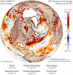
The persistent ridge of high pressure across the western US has helped to set up serious drought conditions in the north central part of the country. As a result, cattle producers are being forced to sell their cattle since it is difficult for them to find food. Familiar story?
This summer’s weather pattern has been anchored in part by cold ocean temperatures off the West Coast, which keeps low pressure anchored and locks the weather pattern of waves into place. The ridge of high pressure in the western US is flanked by the trough over the Pacific Ocean and a second trough of low pressure over the eastern US (the jet stream pattern from Climate Reanalyzer below shows this wave pattern). This eastern trough has been keeping our temperatures mild. So far, this pattern looks like it will continue for the next few weeks, with minor shifts of the western ridge east and west. This could keep the Southeast in a relatively cool pattern (or at least close to normal) and continue to bring rain into the region, which would be great for farmers as long as we get dry days in between storms.


