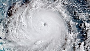
Yahoo News reported today that Hong Kong reported its highest temperature ever on Saturday in 130 years of record. The new high temperature of 36.3 degrees C (97.4 F) came in part due to sinking air outside the circulation of Typhone Soudelor. Typhoon Soudelor ripped up trees and triggered landslides in Taiwan, and knocked out power to 1.5 million homes, before churning towards China (note typhoons are the same kinds of storm as hurricanes but are historically named separately by ocean basin). Mashable has some nice pictures of Soudelor from a few days ago at https://mashable.com/2015/08/03/super-typhoon-soudelor-cat5-monster/. Soudelor is now a tropical storm after passing over Taiwan and heading inland into China.
In the Southeast we sometimes also see this effect from the circulation surrounding a hurricane. Rising air in the center of the hurricane reaches upper levels of the atmosphere and spreads out, cooling and sinking outside of the ring of storms that make up the hurricane. Often when a hurricane is approaching there will be clear skies all around and warm conditions due to both the subsidence and sunny weather. You can see an animation of this circulation here.
