The single most important atmospheric oscillation that affects the climate in the Southeast is the El Nino-Southern Oscillation. You can refresh your memory of what an El Nino is by clicking here.
NOAA’s climate blog has a new entry that explains why the El Nino forecast this year appeared to fail (or “bust” as meteorologists say). El Nino forecasts are made using model ensembles, which give a range of possibilities depending on the models are initially set up. Forecasts are made on the basis of the spread of those models–if the models are all in close agreement, then there is high confidence in the forecast, but if the models spread out a lot, then there is less confidence. Ensemble forecasting is also used in hurricane forecasts and in weather forecasting to look at the range of possible outcomes stretching forward from a given set of observations at one time.

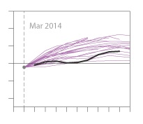
Last March, the ensemble average showed that a moderate El Nino was likely and a strong one was even possible, and that got climatologists very excited. But the reality (shown as the black line in the figure above) was more muted and the El Nino-like conditions never really pulled together into a full-blown El Nino, although some signs were certainly present.
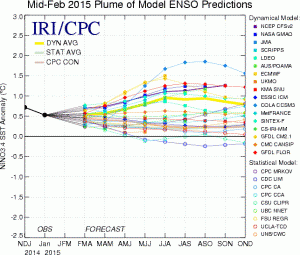
The latest “plume” of ENSO forecasts is shown below. This is available from the International Research Institute for Climate and Society (IRI) at Columbia University (link). The actual value of the sea surface temperature (SST) difference from average is 0.5 degrees C, which is just at the boundary between neutral and El Nino conditions.
The plume shows a range of predicted future values, with most of the statistical models (based on past climate analogs; hollow dots) showing neutral conditions going forward while the dynamic models (based on models which use equations of motion and other physics; solid dots) show that El Nino may develop later this spring. It’s up to the forecasters to decide which models are the best in each particular situation. The solid yellow line shows the average of all the predictions, hovering just about the 0.5 C line, which would indicate a weak El Nino.
