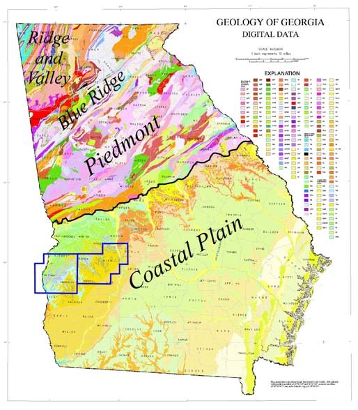
Today as we wrap up National Groundwater Awareness Week, we would like to discuss the geology of Georgia. The geology of Georgia varies from the Coast to the Mountains as you would expect. This difference leads to various aquifers as mentioned on Thursday and determines the main source of water for the residence, agriculture, municipalities, and industry across Georgia. In North Georgia (Ridge and Valley, Blue Ridge, and Piedmont) with the multiple rock formations, the yield or volume of water available can be measured in gallons or 10’s of gallons of water. This volume of water is typically ample for a household. In South Georgia below the “gnat line” (below a line drawn roughly between Augusta and Columbus and through Macon), the geologic formation is the Coastal Plain and the aquifer is the Floridan aquifer. The map below shows these different areas of Georgia, the geologic sections, and the different rock formations. This image is copied from a paper by Mark D. Cocker with USGS (Geologic controls on erosion, sedimentation of streams, and potential for groundwater contamination in Southwest Georgia, presented at the 2007 Georgia Water Resources Conference).
Another image I like to use is the following which shows the typical permeability of aquifers in the different types of aquifers. Not exactly, but generally, the top four aquifer types will be in South Georgia and the bottom four would be in North Georgia.
4-H activities
Some activities for 4-H/Youth could be to “build” these aquifer types and let the students/parents determine before which one would flow water the fastest and the slowest. What could be done is take a plastic container (milk jug, peanut butter jar, or something similar) cut the top off or have an open top and cut a few holes in the bottom (small enough to hold sand but enough to allow water to flow freely OR cut top and bottom off and put screen over the bottom). Fill the container with different things (sand, gravel, clay, marbles, golf balls, similar things) items. Ask which one would flow water fastest. Take an equal volume of water and pour in the top of the container, measure the time it takes to start flowing from bottom and when it stops flowing. You could also catch the volume that comes out to see which would actually hold the most water. These activities could and would show how different aquifers holds more or less water and why we can get more water from a South Georgia well than we can from a well in the Piedmont.
Family and Consumer Sciences
For those families that may have health issues as described in the post on Tuesday, knowing where their well water is coming from (a deep well or shallow well) could help provide information on what tests should help decide what lab analysis should be run.
Today as we close out National Groundwater Awareness Week, we wanted to discuss a little about the geology of the aquifers we have been discussing this week. We hope you learned a little this week during National Groundwater Awareness Week. If you would like to learn more about water issues, please subscribe to the UGA Water Team Blog at https://site.extension.uga.edu/water/ . #UGAWater, #UGAExtension