-
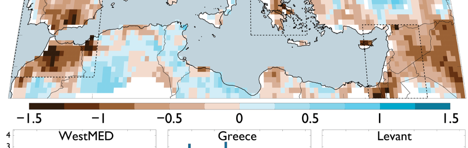
Continuing our look at droughts around the globe, NASA posted a story last month about the drought in the eastern Mediterranean based on some recent research that was published in the Journal of Geophysical Research: Atmospheres. The research showed that based on climate data and tree ring analysis from the region, which includes Israel, Syria,…
-

On my Facebook feed today from the World Meteorological Organization was this incredible photo taken in Alexandra, New Zealand, on Thursday. The thick layer of high cirrostratus cloud combined with some lenticular clouds – which are caused by a strong northwest flow over the Alps – create an eerie spectacle, which is illuminated by the…
Posted in: Interesting weather images -

Jim Angel, the Illinois State Climatologist, noted that today marks the 60th anniversary of the first date that a tornado was seen on radar. Now we have much more sophisticated radars that not only see the storms in multiple dimensions and colors but can also point out flying debris as well as flying birds and…
-

The 7 day QPF map shows that the driest part of the Southeast in the coming week will be the peninsula of Florida, with the driest area farthest south. Light to moderate amounts of rain are expected elsewhere except in Alabama as the next storm system approaches by the end of next week.
Posted in: Climate outlooks -
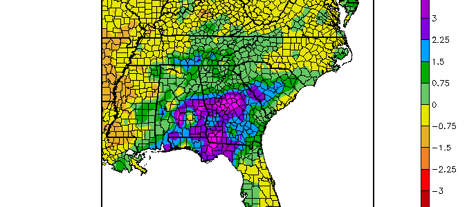
The first week of April 2016 has been much wetter than normal for a significant part of Georgia and surrounding areas. Temperatures have been above normal in southern parts of the Southeast. Colder temperatures for the next two weeks should help bring the temperature closer to normal, although things may warm up at the end…
-

A number of news stories in recent weeks have shown the influence of the waning strong El Niño on climate around the world. Here is a sampling of stories on the agricultural impacts of droughts in some of these areas. News24 reported that drought in Zimbabwe has caused the deaths of at least 19,300 head…
-

Satellite data is the single most important source of weather data used to input into weather forecast models, providing millions of points of information that help to make forecasts accurate. And yet there was a time when there was no man-made satellite looking down on the earth. April 1, 1960 was the first date that…