-
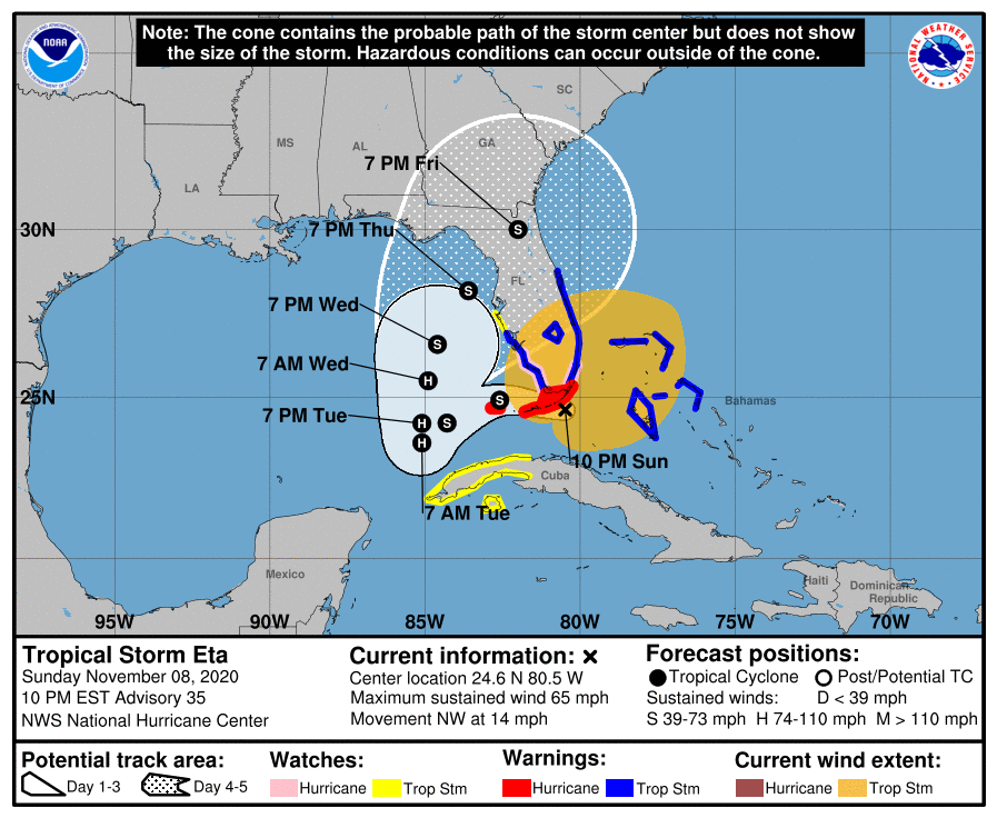
As of 11 pm EST, Tropical Storm Eta is located near the southern tip of the Florida Peninsula, hammering southern Florida with heavy rain and gusty winds. It is moving westward and is expected to move past the Keys and into the eastern Gulf by Tuesday morning. It could become a weak hurricane. At that…
-

The latest monthly climate summary for the lower 48 states was released this week. It shows that for the region as a whole, the temperature was in the middle third of all years since 1895, and the precipitation was exactly average. There was quite a bit of variability across the US, however. The Southeast was…
Posted in: Climate summaries -
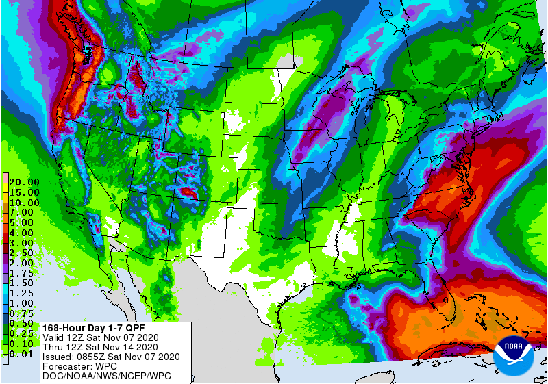
This week’s 7 day QPF map shows that southern Florida and the East Coast will receive the heaviest amounts of rain. That map is dependent on where Eta ends up, so be aware that this could change if the track changes significantly. At the moment, the wettest period for most of the region looks like…
Posted in: Climate outlooks -

The latest monthly climate summary for October 2020 is now available from the Southeast Regional Climate Center. You can find it at https://sercc.com/SoutheastRegionMonthlyClimateReportOctober2020.pdf.
Posted in: Climate summaries -

The latest Drought Monitor, released today, shows that due to the rain from Zeta, all abnormally dry (D0) conditions are gone from Alabama. Isolated areas of D0 also remain in Puerto Rico. dry conditions in Georgia were slightly reduced. Not much change is expected in next week’s map since most rain will occur on the…
Posted in: Drought -

Currently Eta is a tropical depression located over Honduras, where it is dropping torrential amounts of rain after coming onshore in Nicaragua as a major hurricane. But this may be just the beginning of Eta’s journey. The National Hurricane Center is currently forecasting Eta to move to the northeast back over the Caribbean Sea, where…
-
This monthly rainfall map for the Southeast was provided by the Southeast Regional Climate Center using Multisensor Precipitation Estimates. You can find similar maps based on radar-estimated rainfall at https://water.weather.gov/precip/. You can see the tracks of Delta and Zeta and also some rains of over 20 inches in southeast Florida, which is setting records for…