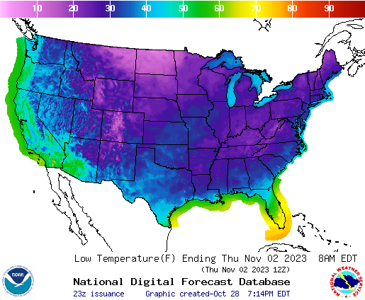
This week we are expecting a big change in the prevailing weather pattern as a strong cold front moves through the region from northwest to southeast on Tuesday and Wednesday. The front will not have a lot of precipitation with it but will bring sharply colder and drier air to a lot of the region from the coastal plains northward. Areas that are first hit by the front on Tuesday can expect to see freezing conditions on Wednesday morning. The lowest temperatures are likely to be in NE Georgia and the Carolina mountains, which could see temperatures dropping into the low 20’s. Areas farther south in the coastal plain could see some scattered frost on Wednesday morning but may not experience freezing conditions.
However, the cold air is expected to continue to move to the southeast behind the front and temperatures on Thursday morning are likely to be colder than the Wednesday morning temperatures across a lot of the area. This will be enhanced by light winds, low dew points, and clear skies that allow heat to escape to space. This pattern of an advection freeze caused by cold air moving into the region followed by a radiation freeze the next night occurs quite often in the Southeast, so do not let your guard down after the first night. The current forecasts do not bring freezing air all the way down to Florida or the East Coast, but temperatures as low as the mid-30s are possible in SW Georgia and SE Alabama as well as the central Carolinas. Some areas could also see freezing conditions on Friday morning. Nearly all of Virginia is likely to experience a freeze except regions right along the coast. The temperatures will be low enough that I think it will mark the end of the growing season for most of the northern part of the region. Areas that do not get down to freezing could still see some frost in areas that approach the mid-30s.
This is just about the average time of the first freeze according to NCEI’s latest discussion of when to expect the first freeze, published earlier this week. Florida should escape the frost this time, but another front coming through about a week later will bring another round of near-freezing temperatures to the region, so producers farther south will need to continue watching forecasts for later freezes. Fortunately, between the two fronts it should warm up a bit, which will help farmers harvest their later planted crops.
Here are a few resources you can use to prepare for the upcoming colder weather:
National Weather Service graphical forecasts: you can pick your own state and look for low temperatures on Tuesday and Wednesday mornings from the main page (for example, here is the link for Georgia https://graphical.weather.gov/sectors/georgia.php).
Commercial Freeze Protection for Fruits and Vegetables: describes the two types of freeze and how to protect against them.
NCEI: When to Expect the First Fall Freeze
UF/IFAS: Tools to Aid Freeze & Cold Protection in Florida Citrus
AgroClimate: Freeze Risk Probabilities