Wednesday, June 1, is the official start of the Atlantic tropical season. And right on cue, a named storm has the potential to develop in the Gulf of Mexico, the prime area for development early in the season. The twist this time is that the energy that could develop is from Hurricane Agatha, which developed in the Eastern Pacific Ocean a few days ago and made landfall in Mexico before dissipating as it moved east. The remaining spin and moisture is now headed for the Bay of Campeche and has a 70 percent chance of becoming a named storm in the next 5 days. Since Agatha dissipated, the new storm, if it pops up, will be called Alex, the first name on the Atlantic list.
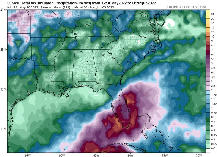
The models are not consistent with their tracks yet, but the National Hurricane Center seems to be leaning towards the European model solution, which brings a wet, sloppy, gusty mess to southern Florida by next weekend (note in the map below an area of 10-15 inches on the southern edge of Florida). They are pretty dry, so that rain could be welcome there. The GFS model is showing less development and a more southern track, so that might mean less rain for Miami. As usual, we will watch to see what happens. In this case there will be minimal impacts for Alabama and not too much for the East Coast, either. The storm is likely to track up the East Coast but should be far enough offshore that the only likely impacts are some high waves and maybe a few showers along the coast.
Here are a few resources you can use this season to keep an eye on the tropics:
National Hurricane Center–the official source for all hurricane watches, warnings, etc.
Brian McNoldy’s blog–good discussions on all things tropical from a Miami hurricane specialist
Mike’s Weather Page (spaghettimodels.com)–dashboard of many charts and graphs on current weather conditions surrounding any tropical activity that is occurring
Bryan Norcross’ blog–Miami-based expert hurricane media specialist and forecaster