We are later than usual for the first frost of fall in a lot of the Southeast. That is going to change next week with a blast of cold air moving into the region. We could see temperatures dip below freezing for parts of the Southeast Monday night into Tuesday morning. High temperatures in Athens are expected to be in the 40s, which will be a nice change. Here is a previous blog post I wrote on where to get frost/freeze forecasts: https://site.extension.uga.edu/climate/2016/11/frost-returns-to-the-southeast/ A map of one forecast for Tuesday morning is shown below, but keep in mind that it is one model run for several days out, so changes are possible. Some models also bring some snow to parts of the region, so that is worth paying attention to as well.

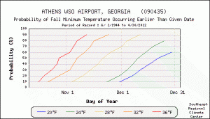
If you are looking for historical information on frost dates, a good place to start is the Southeast Regional Climate Center at https://www.sercc.com/climateinfo/historical/. Click to find your state and nearest station and then look down the left menu to find fall freeze probabilities. I’ve put the one for Athens GA below. Athens’ first 32 F temperature this fall was November 19, which was later than about 90% of all the years as measured at the Athens airport station. You can also get a list of past dates using XMACIS at https://xmacis.rcc-acis.org/.
