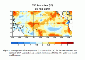
We’ve been watching for months, and today NOAA announced that El Niño has officially returned to the Eastern Pacific Ocean. The temperature conditions in the ocean have been showing a pattern that we expect in a weak El Niño, but until recently the atmospheric pattern did not match up with what we were seeing in the ocean. It also takes 4 consecutive months of El Niño conditions before NOAA is sure that it is not just monthly variability and declares an official event. We have been seeing weather patterns in the Southeast consistent with El Niño in late fall and most of winter so far, particularly in the wet conditions we have been experiencing in most of the Southeast other than the Florida peninsula. Those conditions are expected to continue for the next few months until El Niño fades away later in spring or early summer. There are some signs that we could see a stronger El Niño occur next winter, but that is pretty far ahead to put much confidence in the forecast.
You can read more at Grist at https://grist.org/article/its-official-el-nino-is-back-now-what/ or at Associated Press here. You can also read the official information from NOAA’s Climate Prediction Center at https://www.cpc.ncep.noaa.gov/products/analysis_monitoring/enso_advisory/ensodisc.html.

