Tropical weather
-

The Capital Weather Gang has a thoughtful article today describing the current drought of major hurricanes hitting the US and why it is so worrisome. The streak has reached 3,939 days, two years longer than any previous drought. The drought for Florida is more than ten years, and for Georgia much longer than that. The…
-

William Schmitz of the Southeast Regional Climate Center pointed out a great source of historical hurricane track information to me today. You can find it at https://weather.unisys.com/hurricane/index.php. This provides the best known tracks to hurricanes going back to 1851. (The map below is for 1893 just because it has a lot of tracks on it.) Obviously,…
-

The National Hurricane Center has just announced that they will begin issuing advisories on Tropical Storm Earl, currently located in the western Caribbean Sea and moving west towards Mexico. It is not expected to affect the Southeast or the rest of the US. You can get more information at https://www.nhc.noaa.gov or at https://www.spaghettimodels.com.
-

The water temperature in the Atlantic Ocean is nice and warm, well above the long-term average. But in spite of the warm water, the tropics have been very slow to start producing any tropical storms this year after an early start to the season. In part this is due to the presence of Saharan dust…
-

According to Jonathan Belles of WunderBlog, there have been no hurricanes in the Gulf of Mexico since September 2013. By the end of this week, this will be the longest streak with no Gulf hurricanes on record, dating back to the 1800s. The last hurricane in the Gulf of Mexico was Hurricane Ingrid, which made…
-

The hurricane forecasters at Colorado State University released an updated seasonal hurricane forecast for the Atlantic basin this week, and it shows that that they have increased the number of named storms by one from their earlier forecast. They are now forecasting 15 named storms, the most since 2012. They are also predicting 6 hurricanes…
-
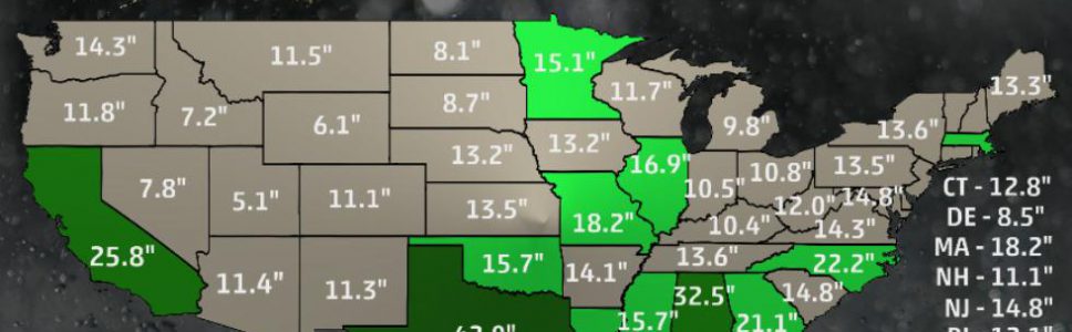
Weather Underground’s latest blog post describes NOAA’s recent infographic, which shows the highest 24-hour rainfall amounts in each state. You can read more about it here. As you might expect, the Southeast has the highest record amounts because the heaviest rain is generally associated with tropical storms or hurricanes coming onshore and dumping prodigious quantities of…