Climatologists around the country have been watching the development of El Nino over the last year. In 2014 we thought a strong El Nino might be starting, but the pattern never quite developed the “oomph” needed to cross the threshold into official El Nino territory. However, many of the climate impacts we saw in the last year can be traced back in part to the presence of that pattern. Now, an official El Nino is underway and is expected to continue and perhaps strengthen in the coming months. Here are three blog postings which provide insight into the current El Nino and what it might do.
Cliff Mass of the University of Washington provides commentary on the current El Nino and what a strong El Nino might mean for California and the Pacific Northwest at https://cliffmass.blogspot.com/2015/04/is-strong-el-nino-finally-coming.html.
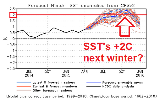
Paul Huttner of Minnesota Public Radio News posted a blog on El Nino’s development and how the forecast shows a good chance of reaching the category of “strong” at https://blogs.mprnews.org/updraft/2015/04/can-long-anticipated-super-el-nino-save-california/.
And last but not least, David Zierden, the Florida State Climatologist, posted an article today on the Southeast Innovative Farming Team site at https://www.siftag.org/el-nino-strengthens-for-another-round-spring-rains-and-potential-summer-dryness/ describing his take on the current El Nino and what it means for farming in the Southeast, and in particular the Tri-State area of Alabama-Florida-Georgia. Among the topics he discusses is the recent rainy conditions and the chance for dryness in late fall. In El Nino years, hurricane activity in the Atlantic is lower than usual, leading to the chance of dry conditions later in the growing season.