For most of the day on September 25, Tropical Storm Ian was looking disorganized because dry air at mid-levels in the atmosphere were keeping it from building vertical convection needed to strengthen the storm. However, the winds have increased this evening and the storm structure is expected to tighten over the next few hours as conditions become more favorable and the sea surface temperatures increase. It may be a hurricane by morning. UPDATE: Ian became a hurricane overnight as expected.
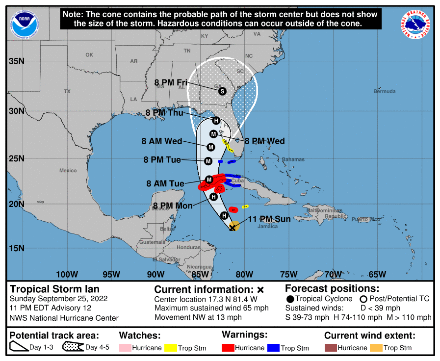
The latest forecast cone shows that Ian is still expected to become a major hurricane in the Eastern Gulf before it starts to weaken as it moves closer to shore somewhere in western Florida. Most of the states of Georgia and South Carolina as well as southeastern Alabama are now covered by the 5-day cone as well as most of Florida with the exception of the southeast, although impacts will occur well outside the cone where the center is likely to go, especially on the right side of the storm. The forecast cone is likely to continue to change as the models are refined by additional data from weather balloons and other observations and as the larger atmospheric pattern evolves, so do not focus on the line down the middle of the cone but consider preparations if you are anywhere near the area of concern.
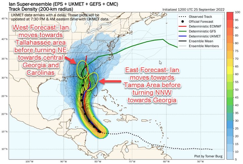
After the first 2-3 days, the forecast becomes much trickier, as I show in the second diagram below. There are two groupings of model outcomes, and the impacts at any location will differ depending on which track turns out to be correct. If the western track proves right, we will see more impacts on the Florida panhandle and southwestern Georgia, where farmers have busy been harvesting crops this weekend in advance of the storm. In that scenario, Georgia could get several inches of rain along with gusty conditions and likely power outages from falling trees and power lines. If the eastern scenario proves correct, that will mean worse erosion along the Georgia and South Carolina coasts and more intense winds along the East Coast but less rainfall and lighter winds in SW GA and SE Alabama, although they could still be strong enough to cause damage. The current forecast cone is a blend of the two solutions since we don’t know which will be correct.
Any of you who are in or near the forecast cone, especially those on the right side, should be prepared for extreme winds, heavy rain, some isolated tornadoes, and extended power losses due to tree and power pole damage. You should have food and water available for your family, pets and livestock to last for a few days. Make sure your vehicles are fueled up, especially if you are planning to use them to evacuate. Keep them away from trees and low-lying areas where they could be flooded or damaged by wind-blown debris. Those along the coasts should plan for water being pushed onshore by the winds and storm surge, especially if you are close to the center of Ian–this includes those along the Florida East Coast and the coastal areas of Georgia and South Carolina, especially if Ian takes a path that is on the east side of the cone. If the center of circulation is located along the center of the cone as it gets near Tampa, they could have a significant storm surge that could cause widespread damage there. Heavy rain is likely to continue along the path of the storm even as the winds die down over time, especially in mountainous areas. I haven’t talked much about the Carolinas and Virginia but they are all likely to see impacts of Ian later in the week after it moves through Florida and Georgia, but those depend to a large extent on the path Ian takes.
For those of you who have cotton or peanuts near harvest in the forecast cone, here is some advice from our UGA cotton and peanut specialists Dr. Hand and Dr. Monfort tweeted out by our plant pathologist Dr. Bob Kemerait that you might find useful: “If the cotton was defoliated in past week, pick ASAP particularly if the variety is prone to “falling out”. If not, defoliate after the storm. Dig peanut fields risky to disease, poor stem strength, over mature & nuts coming loose in hull. If the vines are healthy, leave them in the ground for now.”
The timing for the center of the storm is shown below, but impacts will start long before the center gets close to you. I expect rain to start in SE Georgia by Wednesday evening, although we could see scattered rain even before then. Tropical storm force winds could occur along the Northern Gulf Coast as early as Wednesday morning but are more likely to arrive late in the day on Wednesday or overnight into Thursday morning and will move north over time. That gives you time to take care of last minute preparations, including bringing in loose outdoor items like lawn chairs and documenting crop condition for potential loss calculations if you have time.
I will post my next update on Monday night after the 11 pm maps come out.