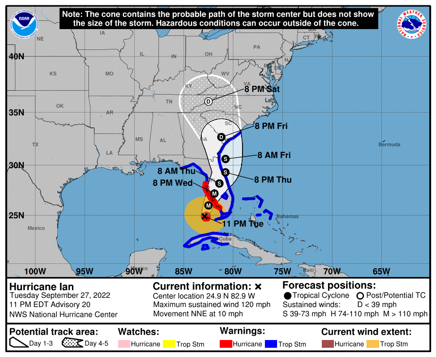
Over the course of the day, Hurricane Ian crossed over the western end of Cuba, strengthened over the Gulf and slowed down. Rainfall has hit southern Florida hard along with numerous tornadoes that have caused local damage. The forecast models have shown the cone drifting to the right over most of the day, which means Ian will hit Florida farther south than previous forecasts, and Tampa is now expected to be north of where the landfall will occur.
In the last few hours Ian has been going through an eye wall replacement cycle, is resulting in an eye and area of strong winds that is larger than earlier in the day, just hours before it hits the Florida coast. This could result in severe damage from winds and storm surge along the Florida coast, most likely south of Tampa, ahead of landfall sometime on Wednesday afternoon. After that, it is expected to weaken as it moves northeast across the Florida peninsula towards the northeast Florida coast. The forecast shows that it is possible that the storm will emerge over the Atlantic Ocean briefly before making another landfall in Georgia or South Carolina, but it could also stay just onshore before it curves back to the northwest and continues to weaken. By Saturday night, it should be exiting North Carolina headed towards the north.
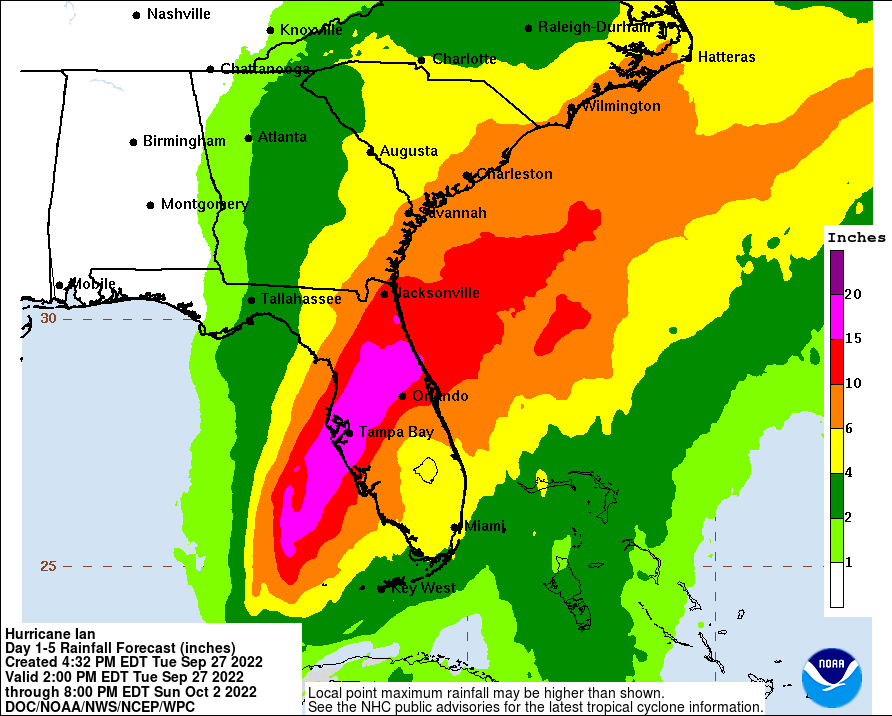
On Wednesday, rain will continue to move north and should start falling in southeastern Georgia later in the day. Meanwhile, the slow speed of Ian will mean tremendous amounts of rain falling in Florida (15-20 inches), causing freshwater flooding in addition to the storm surges that will occur along the SW Florida coast and later along the East Coast (although these will be lower due to the weakened storm). Because of the more eastern path of the storm and the lower speed, rainfall amounts along the path of the storm, including the GA and Carolinas coasts are now expected to be more than 6 inches. This will increase coastal flooding due to streamflow coming down the rivers at the same time that the storm surge is pushing inland. Rainfall should decrease from east to west and little if any rain will fall in Alabama.
Tropical storm force winds are not expected to occur in Georgia until Thursday, and will be enhanced because of a strong pressure gradient due to high pressure to the north over the next couple of days. Windy conditions will continue overnight into Friday, and Friday should be wet and gusty along the path of Ian most of the day, especially near the center of circulation. Windy conditions will exist far outside the forecast cone, however, due to the strong pressure gradient.
While the forecasts are converging to some extent, there is still variation in where the models are showing the track of Ian, as well as its strength and size, so you can continue to expect some additional shifts in the forecast cone and related impacts.