Update 7:30 PM on April 19–Rain-cooled air in central GA has stabilized the atmosphere and kept the warm front to the south. That meant less chance of supercells this afternoon, and severe weather down south has been isolated. However, the main system is still to the west and has plenty of energy for storms, even with the cooler air, so continue to be prepared overnight. The latest NWS briefing is at https://www.youtube.com/watch?v=yLooLcaVo1k&feature=youtu.be.
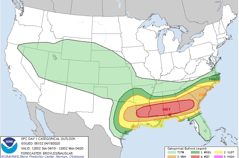
The latest update from the National Weather Service indicates that severe weather is still expected to occur on the afternoon of April 19 and through the night of April 19-20, 2020, particularly in the area of Georgia south of I-20. Currently, areas north of I-20 are expected to be at lesser risk and their highest impacts will likely come from heavy rain which could cause localized flooding. If the warm front moves farther north than expected, the severe weather threat will also shift northward.
The severe weather may come in two rounds, one on Sunday afternoon as the warm front moves north through the area, and the second one overnight with a large area of stormy weather which could include severe thunderstorms and a few smaller tornadoes. In the area where the warmest air occurs, supercell storms could cause heavy hail and potentially long-track tornadoes. The highest risk will be in western Georgia but anywhere, especially in the southern 2/3 of Georgia, could experience severe weather. Hail is also most likely in the afternoon storms. A second round of severe weather is expected to move through the state overnight and should be passing out of southeast Georgia on Monday morning. In this time period, strong straight-line winds could cause most of the damage although brief spin-up tornadoes are also possible. Strong winds can do as much damage as a tornado, so do not downplay a Severe Thunderstorm Warning if you get that instead of a Tornado Warning.
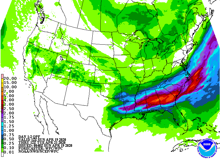
Another issue to consider in this outbreak is the potential for very heavy rain. Central Georgia could see as much as 4-6 inches in some spots if training of thunderstorms occurs. North and South Georgia are likely to see smaller amounts of 1-2 inches. If your ground is already wet and you have equipment, hay or animals in low-lying areas that are prone to flooding, you should consider moving them to higher ground. Trees are more likely to be blown over if the ground is wet, so prepare for the possibility of power outages from these storms, too.
If you want to monitor the progress of the warmest temperatures on Sunday, you can use the UGA Weather Network at https://www.georgiaweather.net/?content=si&variable=XT or the National Weather Service office for your location. To view the NWS video briefing, you can find it on their YouTube channel at https://www.youtube.com/user/NWSPeachtreeCity or view their slides at https://www.weather.gov/ffc/briefings. They have posted a new briefing on Sunday morning at https://www.youtube.com/watch?v=1wCJu7XsODM.
I do not plan to post a update on my blog on Sunday but encourage you to follow the weather through NWS guidelines for your area and take precautions such as using your NOAA weather radio and smartphone apps. Remember to figure out a way to get the warnings overnight while you are sleeping, as I discussed last week. Also keep in mind that we may see another round of severe weather later this week, so continue to monitor weather forecasts for changing conditions.