I sent out this email to my Extension colleagues in Georgia at noon today. Still valid as of 9 pm tonight.
Key points:
- The current forecast path of Hurricane Florence reduces but does not eliminate the direct impacts of the storm on Georgia, including high winds, storm surge, and heavy rain.
- There is still considerable uncertainty in the forecast path, so you should not assume that the current forecast path will be correct. Continue to monitor the National Hurricane Center forecasts several times a day and follow the recommendations of your local emergency managers.
- Even if Hurricane Florence does not hit Georgia directly, we are still likely to see gusty winds with some tree damage and power outages, the potential for isolated heavy rain, and a lot of traffic from evacuees driving into Georgia from the areas directly affected by the storm winds and flooding rains.
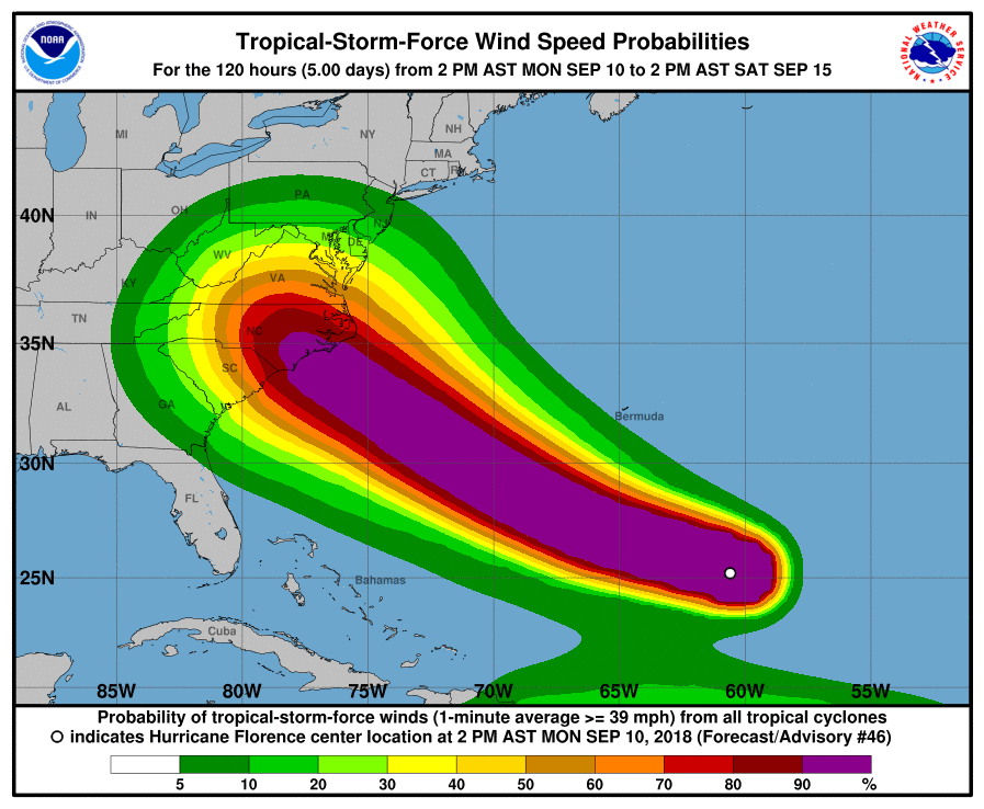
This is an update on Hurricane Florence, which is now out in the Atlantic Ocean headed west towards a likely landfall which is currently projected to occur along the coast of North Carolina sometime Thursday evening as a major hurricane. A few minutes ago, Hurricane Florence was upgraded to a category 4 storm, with sustained winds near 130 miles per hour and higher gusts, and has the potential to strengthen even more before it hits the coast. This is going to cause catastrophic effects along the coast where a large storm surge is likely to hit near and to the right of the storm’s path. At the moment Georgia’s coasts are already experiencing some waves from the hurricane and those will get larger as the storm gets closer, but no large storm surge is expected for Georgia if the storm remains on the forecast path. However, it is too early to let your guard down Georgia because the forecast track errors this far ahead of landfall are quite large and if the storm follows a more western path Georgia could feel the direct impacts of storm surge and high winds from Florence. Keep abreast of changing forecasts from the National Hurricane Center, the National Weather Service, and follow instructions from your local emergency managers. Wherever it hits, the damage from Florence is going to be catastrophic.
A second, potentially even worse threat from Florence will come from heavy rains which will fall continuously over a wide area for several days, since the steering currents that are moving the storm along are expected to collapse, leaving the center of the storm drifting over the same area for up to a week. This is similar to the behavior of Hurricane Harvey over Texas last year, and could drop similarly large amounts of rain in some areas. I have seen some forecasts of 48 or more inches over a wide area over a few days. Since the western Carolinas are not flat like coastal Texas, rivers will rise rapidly and flood waters will move more swiftly down streambeds, potentially causing damage to properties, roads, and buildings far outside the 100 year flood plain. If the storm track brings the center of circulation closer to Georgia, we could see some of that heavy rain as well, particularly in the northeast mountains where slopes are particularly steep and rainfall amounts will be enhanced by the mountains.
If the present forecast track continues, then I think Georgia will largely be spared the worst effects of the storm. If you are in southern and western Georgia, you will see few impacts. If you are along the coast, waves will be high and rip currents will be likely, but winds blowing offshore will keep a large storm surge from moving onshore. If you are in the mountains, you are likely to see some spotty heavy rain and windy conditions as the storm center meanders over the area after landfall. If you are anywhere else in eastern Georgia, you may see some gusty winds that could knock out power to some locations from falling trees, but rainfall should be relatively light due to sinking air outside the main circulation of the storm, and skies could be sunny and cloudless. Remember that when Superstorm Sandy was coming onshore in New Jersey in 2012, our winds in northeast Georgia were strong enough to cause scattered power outages and at least one injury in the area from falling tree limbs; Florence is stronger so you should be prepared for some power outages and tree damage even if the storm does not come near us.
The severe impacts of the storm on the Carolinas will impact Georgia in secondary ways. Some of the large number of people that will evacuate from Florence will be headed towards Georgia, since it will be dangerous for them to evacuate inland into the area of heavy flooding. That means traffic along major roads such as I-95 will be heavy and there will be a high demand for gas, lodging and other shelters for both people and pets (including horses). They may need to stay out of the flooded areas for weeks or even months if their neighborhoods are covered by water, so supplies of water and food are likely to be needed for a lengthy period of time. Bridges along most roads including the interstates may be washed out in the significant flooding, causing problems for transportation up and down the East Coast as road closures divert traffic onto other roads until the bridges are inspected and judged safe.
I do not plan to send out another email unless the path of Florence changes and we start to see a trend towards a direct hit by Florence in Georgia. You should always be prepared for a hurricane or other storm in Georgia well in advance of any tropical storm activity, including having supplies of fresh water and food for several days. We are only halfway through the Atlantic hurricane season, and the tropics have become much more active since August, so this may not be the last storm we see this year.