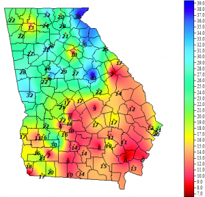
Roger Gates, Extension ANR agent in Whitfield County, wrote me to ask for help in finding soil moisture data because he was struggling to fill out the soil moisture survey for the weekly Crop Progress and Condition Survey. I asked him if it would be OK to share his question and my answer because a few other readers may be having similar problems. Here is my answer below along with today’s soil moisture map from the UGA automated weather network.
There are not many active soil moisture sensors around except for those on the UGA weather network. And of course there is no UGA station in Whitfield County. Here is the link to their current soil moisture map, for what it is worth.
Here is a list of other soil moisture sites from the Drought Portal. Some of these are surface-based from instruments and others are satellite based, which would be more useful for Whitfield County.
The streamflow data is collected by the US Geological Survey. The general water page is at https://waterwatch.usgs.gov/. You can see a map of current streamflow conditions for Georgia at https://waterwatch.usgs.gov/?m=real&r=ga&w=map. If you click on the stations in your county, you will get a summary page, and you can click on the station ID number to get more detailed information about the streamflow at that gauge and look at past data.
