When I called my mom in Michigan today, she talked about how much snow they were getting. She lives (and I grew up) in western lower Michigan, where lake-effect snow often falls this time of year. In fact, this year the snow is especially heavy because the Great Lakes have been and still are well above normal in temperature. When the cold Arctic air that we have now moves over the warm water of the lakes, it picks up a lot of moisture and dumps it as snow once the air gets back over the colder land.
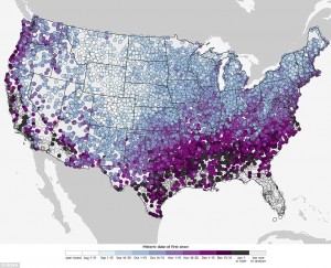
NOAA has put out a new interactive version of their map of first date of snow at https://www.climate.gov/news-features/blogs/beyond-data/first-dates. If you look at the map, you can see that areas east of Lake Michigan get snow earlier than west of the lake or on the east side of the lower peninsula because they feel the effect of lake effect snows before other areas get their snow.
For my hometown of Athens, GA, the average date on which they have at least a 50% chance of experiencing 0.1 inch of snow is December 12 (note that this is slightly different than the average date of the first snow–read the blog post above by Deke Arndt for a more technical explanation). So historically we have had at least a little snow by now in half the years from 1981-2010 in Athens.
You might wonder if snow will become more rare as temperatures get warmer under global warming. Another NOAA post from March 2015 discusses that here. In fact, with warmer temperatures, it is easier to get more moisture into the air, and that could potentially lead to more snow if the temperatures are still below freezing. As we are seeing in Michigan today, warmer lake temperatures are leading to heavier snow along the snow belt, so it’s not a straightforward relationship.
