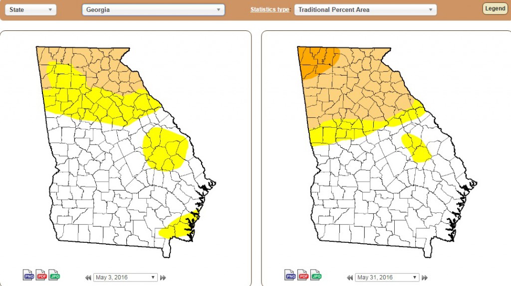
While record-setting rain fell in Savannah, most of Georgia suffered from a lack of rainfall in May. The result: drought expanded across the state, and severe drought was introduced into the northwest corner of the state by the end of the month.
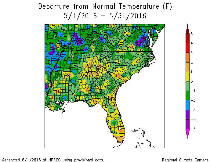
Temperatures at most locations were near normal in May. In Atlanta, the monthly average temperature was 71.1 degrees F (1.0 degrees above normal), in Athens 70.3 degrees (0.3 degrees above normal), Columbus 72.5 (0.5 degrees below normal), Macon 71.8 (0.1 below normal), Savannah 74.0 (0.7 above normal), Brunswick 74.9 (0.4 above normal), Alma 73.0 (0.7 below normal), Augusta 70.7 (0.4 below normal), Albany 74.5 (0.0 above normal), Rome 69.0 (0.8 above normal) and Valdosta 73.9 (0.1 degrees above normal).
Brunswick tied a record low of 50 F on May 6 (previous record in 1973) and a high minimum temperature of 73 F on May 2 (previous record in 2012).

Wet conditions plagued Savannah and surrounding counties in May, but most of the state was drier than normal, leading to an expansion of drought over the month. The highest monthly total precipitation from National Weather Service reporting stations was 8.99 inches in Savannah (6.01 inches above normal) and the lowest was in Albany at 0.78 inches (1.91 inches below normal). Atlanta received 1.25 inches (2.42 below normal), Athens received 2.49 inches (0.51 inches below normal), Columbus received 2.51 inches (0.68 below normal), Macon 1.96 inches (0.76 below normal), Augusta 5.71 inches (3.06 above normal), Alma 3.34 inches (0.87 above normal), Brunswick 1.68 inches (0.18 below normal), and Valdosta 3.45 inches (0.92 above normal).

Savannah received most of their monthly rainfall in mid-month. The NWS station set a new daily record on May 17 when 2.29 inches fell, breaking the old record of 1.62 inches set in 1980. Augusta broke a daily record on May 29, receiving 2.28 inches, breaking the old record of 2.08 inches set in 2001.
Snow flurries were observed on webcams and by traveling CoCoRaHS observers at some higher elevations in the northeast mountains on May 5 as cold air aloft caused snow showers to develop, but none of the Georgia stations reported snow at their station locations.
The highest single-day rainfall from CoCoRaHS stations was 8.65 inches south of Savannah in Chatham County on the morning of May 18, followed by 7.59 inches received on Skidaway Island, also in Chatham County. Many other stations in that area received over 5 inches on that date. The highest monthly total rainfall was 14.34 inches observed in Newington in Screven County, followed by 12.70 inches near Marlow in Effingham County and 10.15 inches observed by the Savannah observer with the highest daily amount. On the other end of the spectrum, one CoCoRaHS observer in Grady County in southwest Georgia reported that he had received only 0.73 inches for the whole month.
Severe weather was reported on ten days during May. One EF1 tornado was observed in Chatham County on May 17.
In the dry areas of the state, pastures, livestock and summer row crops suffered due to lack of rainfall. Some farmers were waiting for rain to finish planting dryland crops and corn farmers with irrigation were using water liberally to keep the plants developing optimally. In central Georgia where wet conditions occurred in April, some fungal diseases were observed.
Growers from commercial peach growers around Georgia noted that the combination of cold weather in January and late February coupled with mild weather in March has helped them produce their biggest peach crop in years. As Growing Georgia noted, “It’s going to be a peachy summer in Georgia.”
By the end of the month, drought conditions expanded in northern Georgia and severe drought was introduced to the northwest corner of the state.
The outlook for June through August shows an enhanced chance of warmer than normal conditions. Dry conditions may continue in northwest Georgia in June although there are no trends determined for the summer period overall. Colder than normal water in the eastern equatorial Pacific Ocean means that El Nino is almost gone and neutral conditions should be declared soon before a likely swing to La Nina later in summer. The Atlantic tropical season began with the development of Tropical Storm Bonnie in late May and is likely to be normal to above average in activity this year with neutral or La Nina conditions present.
For more information please see the “Climate and Agriculture” blog at https://site.extension.uga.edu/climate/ or visit our new web page at https://www.gaclimate.org. Please feel free to email your weather and climate impacts on agriculture to share on the blog to pknox@uga.edu