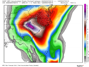
The latest forecast for rainfall from the current combination of weather events is shown below. Note that the general pattern and amount of rain expected has not changed. The NWS is still expecting historic rainfall amounts in South Carolina and heavy rain in adjoining areas of North Carolina and Georgia. Slight changes in the weather patterns could move the bulls’ eye around so prepare for the worst and hope for the best.
The flow into the region of maximum rainfall has been described by Dr. Marshall Shepherd of UGA as an “atmospheric river”. I’ve talked about them in this blog before but in the context of heavy rain in California and the West Coast, not in discussing weather in the Southeast. You can read his discussion at Forbes here.
The pattern of inflow is also discussed in the CIMSS Satellite blog from the University of Wisconsin here with some good satellite imagery. The Weather Underground talks about how this could be a “1000 year storm” for some locations and provides an update on Joaquin here.
As in my earlier posts, drive carefully and “turn around, don’t drown” when you see water moving across the road. If you are in a low-lying area, protect property and animals and get to a safer place until the water goes down.
