In addition to the mesonet run by the University of Georgia (https://www.georgiaweather.net), there are two other mesonets in Georgia. One of them is the Georgia Forestry Commission mesonet. You can access their data at https://weather.gfc.state.ga.us/.
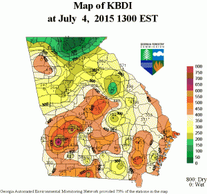
This network has 19 weather stations scattered around the state. It provides information on current and historical weather as well as a variety of maps on fire conditions. For example, the KBDI map below (Keetch Byram Drought Index) identifies the areas that are most vulnerable to fires based on climate conditions. Areas above 500 are expecially vulnerable. This is a great source of information if you are thinking of doing any burning to see if conditions are appropriate.
