When severe weather hits, the National Weather Service collects the information and issues Local Storm Reports for the storm events that are called in. They are usually posted on each station’s web site. However, they are text files and it is not always easy to find a report for a specific location.
There are several sites which have the information in a map format to make it easier to find later when you are looking for information for insurance or other reasons. Keep in mind that severe weather may have occurred but does not appear in the database if no one reported it. There may also be duplication if several reports were made on the same event.
The NOAA Storm Prediction Center collects these reports from NWS stations around the United States and compiles them at https://www.spc.noaa.gov/climo/online/. The Storm Prediction Center also issues watches around the country, although warnings are sent out by individual NWS offices. (You DO know the difference between watches and warnings, right? If not, read this article on watch vs warning from The Vane).
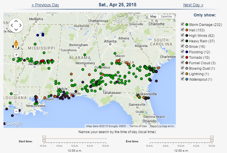
The NWS San Diego office has an experiment product that you can use to find storm reports overlaid on a Google map at NWS San Diego severe reports map. It has a variety of search parameters to narrow down the type of severe weather and the range of dates desired.
The State Climate Office of North Carolina also maintains databases of storm reports from the Storm Prediction Center for the entire US. The provide two different types of reports which are summarized here on https://climate.ncsu.edu/storm_reports.php. The Local Storms Database is searchable and resizable and also offers a video tutorial.
Two more sources that you might find useful: NOAA’s Severe Weather Data Inventory and the National Climatic Data Center’s Storm Events database (currently available through December 2014).