Yesterday’s USDA Agricultural Weather Highlights mentioned that much of the Eastern US is under the influence of the Bermuda High, which is continuing to cause hotter and more humid conditions than usual. What is the Bermuda High and how does it affect the weather and climate of the Southeast?
A simple explanation is provided by USA Today at https://usatoday30.usatoday.com/weather/whothumd.htm:

Source: USA TODAY research by Chad Palmer
A semi-permanent area of high pressure, commonly known as the Bermuda High, forms over the Atlantic Ocean during the summer and is the key weather player for most of the eastern USA. The clockwise circulation around the high brings hot, humid wind to the East, especially the Southeast. The main storm track shifts to the north in the summer, so storms are generally too weak to drag cooler air all the way into the Southeast. This often leads to many weeks of hot, humid weather with little or no relief in the Southeast. Ocean waters that are cooler than land cause the Bermuda High to form and maintain its strength during most of the summer.
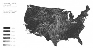
You can also see the clockwise circulation around the western edge of the Bermuda High in the Southeast on this wind map found at https://hint.fm/wind/. Click on the link to see the full animated effect. At the same time, you can see the strong counterclockwise circulation around the low pressure center in the northern Plains that is contributing to the waves of severe weather they have been experiencing this week. As long as we are under the influence of the Bermuda High, light winds from the south, scattered thunderstorms and warm and humid conditions will be the norm across the Southeast.
