Interesting weather images
-

The New York Times has an interesting photo essay on farmers who live and work at the edge of the Gobi Desert. These farmers are dealing with increasing numbers of sandstorms and the erosion of their way of life. You might enjoy the haunting imagery in this article. You can view it at https://www.nytimes.com/interactive/2016/10/24/world/asia/living-in-chinas-expanding-deserts.html?ref=oembed&_r=0. https://www.nytimes.com/interactive/2016/10/24/world/asia/living-in-chinas-expanding-deserts.html?smid=tw-share&_r=0
-

While Hurricane Matthew is now one for the record books for most people (other than those in eastern North Carolina still dealing with the devastating floods in the region associated with the storm), there have been a lot of interesting stories about the storm. Many of these are on scientific aspects of the storm such…
-
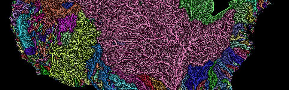
If you like maps as much as I do, you will be excited to see this amazing map showing all of the river basins in the US in color. The basin that stands out in the US as a whole is the Mississippi River basin in pink, which dominates much of the country. In the…
Posted in: Interesting weather images -
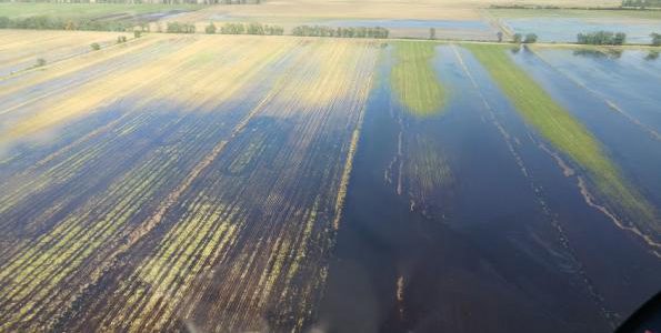
The Southeast Farm Press had an excellent slide show on damage to North Carolina farm fields caused by the flooding from Hurricane Matthew here. Many fields were completely submerged, ruining soybeans and cotton as well as other crops. These pictures were taken by Hyde County Extension Agent Andrea Gibbs. She credits helicopter pilot Sid Cayton of…
-

Here’s a cool video on YouTube from NASA.gov which shows the progression of rainfall along the path of Hurricane Matthew. This animation shows the amount of rainfall dropped by Hurricane Matthew over the life and track of the storm/ IMERG real time data covering the period from Sept. 28 through Oct. 10, 2016 show rainfall from…
-
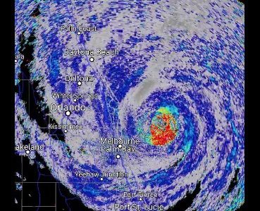
Here are a selection of the amazing images I’ve seen today from Matthew. This doesn’t even count all of the videos of water surging through Daytona and Jacksonville and the spectacular data from Matthew passing over ocean weather buoys. Birds in the eye of Matthew. Click here for the animated version. A variety of still…
-

Red sprites are a high-altitude extremely rapid lightning discharge that happens over thunderstorms. According to a recent National Geographic post, “sometimes called “upward lightning” and “cloud-to-stratospheric lightning,” sprites are momentary bursts of electricity that can literally reach the edge of space, about 50 miles above the ground. They’re rarely documented because they are so short…