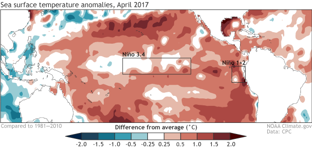
“Will he or won’t he?” A question I’ve been getting a lot lately is whether or not we are headed into our next El Niño. Fortunately for us in the Southeast, if we have either an El Niño or the opposite La Niña, statistically we have some idea of what climate conditions to expect during the winter months. But NOAA’s latest outlook, published yesterday, puts us at just at just under 50% chance of going into an El Niñ0, with another near 50% chance we won’t. Doesn’t look like La Niña is a likely option in the coming year.
This is a pull-back from earlier forecasts, when strong ocean warming in the eastern Pacific Ocean made it look like a new El Niño might be developing. But those conditions have disappeared and the current forecasts make it look like we will be hovering near a 0.5 degree positive anomaly. For an official El Niño to be declared, we have to have several months of ocean temperature anomalies of over 0.5 C, so we may be flirting with El Niño-like conditions even if one does not officially develop. Now that we are over the spring prediction barrier, we should have a clearer view of what will happen in the eastern Pacific for next fall and winter. Stay tuned!
Also note in the sea surface temperature map below the warmer-than average temperatures across a wide portion of the Pacific and Atlantic Oceans, which may help fuel tropical storm activity if the dynamics are right.