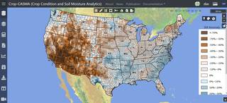
Earlier this week, the USDA released a new soil moisture tool that is powered by NASA satellite data. The Crop Condition and Soil Moisture Analytics (Crop-CASMA) app provides access to high-resolution data from NASA’s Soil Moisture Active Passive (SMAP) mission and the Moderate Resolution Imaging Spectroradiometer (MODIS) instrument. It will help researchers, meteorologists and farmers track droughts and floods, and better forecast agricultural yields. It allows you to look at soil moisture on an interactive map that will let you zoom in on you area of interest to see how the soil moisture varies over time and space. You can read more about it at https://www.nasa.gov/feature/goddard/2021/nasa-data-powers-new-usda-soil-moisture-portal and https://www.meteorologicaltechnologyinternational.com/news/agriculture/nasa-soil-moisture-data-tool-to-help-increase-crop-yields.html.
The direct link to the tool is https://cloud.csiss.gmu.edu/Crop-CASMA/. It is free to use.