My UGA colleague Bob Kemerait and several others all asked me why it was so cold and rainy in Georgia earlier in August. Here is what I wrote him:
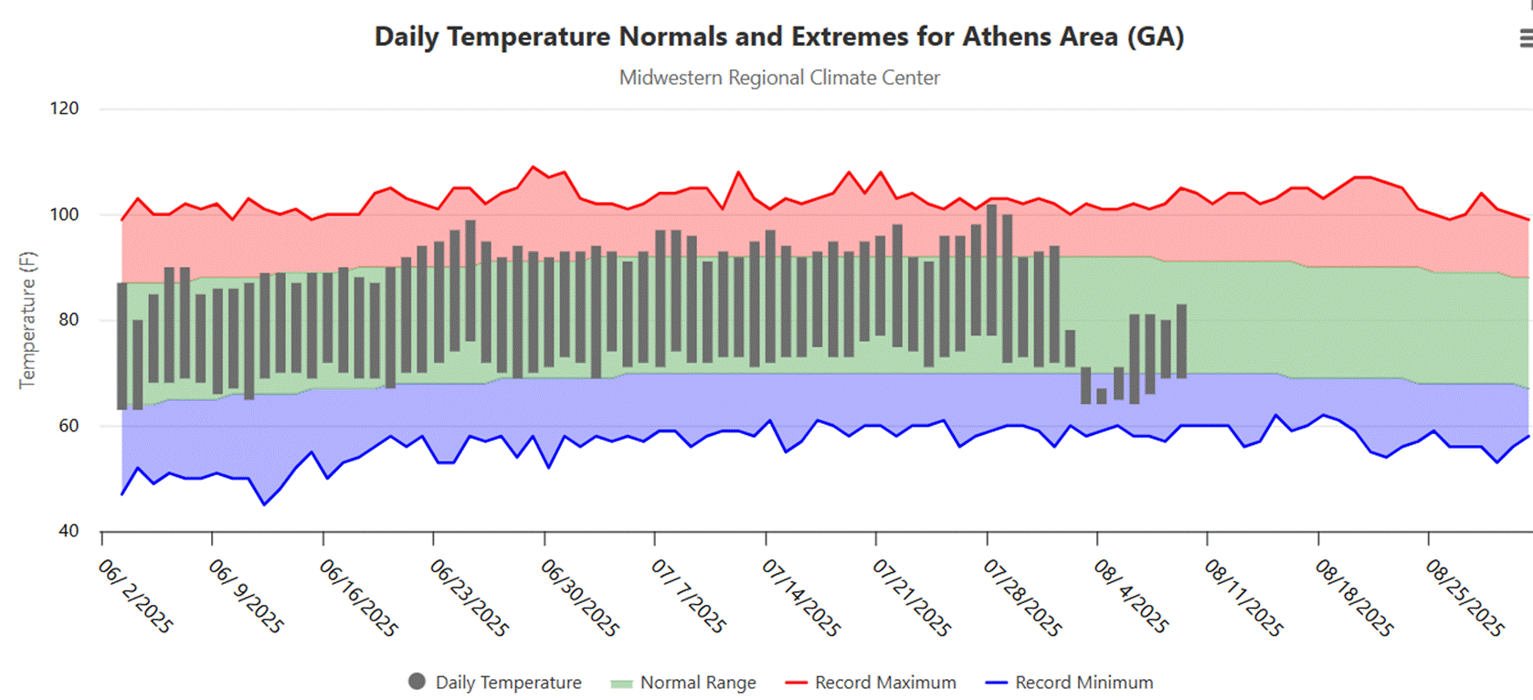
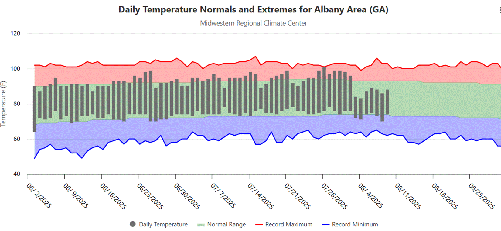
I have attached thermographs of Athens and Albany temps below (the Tifton NWS station is missing most of August so far). The first part of summer was very typical summer weather for Georgia, with highs in the 90s, heat indices occasionally in the 100s due to the humidity, and lows above normal because of the higher humidity. This is typical because usually Georgia is under high pressure for most of the summer due to an expansion of the Atlantic subtropical high westward over the warm land in summer. Note that almost every day was a little bit higher than the long-term average (green band), which is a sign of a warming climate.
However, right around August 1st there was an abrupt change to a winter-time pattern because of a shift to a high pressure center over Greenland and eastern Canada which pushed cold air down the east side of the Appalachian Mountains into Georgia from the NE. We call that “cold air damming” because the mountains prevent the air from moving west, so it all comes barreling down the east side of the mountains into GA from the NE. Warm air (less dense) from down south rode up over the top of the wedge of cold air (more dense), dropping over 10 inches of rain in Athens (mostly stratiform rain) and producing thunderstorms and rain near the edge of the wedge in south Georgia. You can see from the thermographs it was stronger in Athens than in Albany, and this is pretty typical. Sometimes the wedge does not make it to SW Georgia at all.
This wedge lasted a few days before it began to erode from the south and more typical summertime weather has started to return to the area, although it has not been as warm as it was previously. Why did the pattern shift? I don’t know. It is not unusual to get a wedge like this in summer, although they are much more frequent in winter, and they don’t always reach down into SW Georgia, so the strength of this wedge was unprecedented. I have not read anything yet that can explain why it happened other than the shift in the planetary highs and lows that control the surface wind directions and subsequently brought cooler air down from the northeast with it. I am sure atmospheric scientists are looking at it now but no answers so far.
Why is it still cooler now? I think it is most likely a residual effect of having all that rain. It takes more energy to warm up wet soil and evaporation also causes more clouds, which also keeps things cooler. It is raining now here in Athens, appears to be coming from a circulation off the East Coast that is bringing rain in from the east today.
I added some additional information the next day: The pattern that is bringing the wedge of cold air from the NE is linked to a large ridge of high pressure over central Canada, where there is a moderate drought and a lot of forest fires. This ridge is at 500 mb, about halfway up in the atmosphere. The surface high pressure center is over Quebec. Air is moving out from the surface high towards the south and getting funneled by the mountains. It has been pretty persistent over time. So you can probably link our unusual weather to the strong ridge of upper level high pressure and surface high pressure over Quebec to our cold weather.
You can see the drought map for Canada at https://droughtmonitor.unl.edu/nadm/Home.aspx

If you are interested in learning more about wedge-type events, you can check out my older post on the wedge at https://site.extension.uga.edu/climate/2019/08/the-wedge-is-back-in-northeast-georgia/. It is not rare to get a cold-air damming event in the Southeast, although the one we had was unprecedented in its strength considering it was in the middle of the summer. The amount of rain we got in parts of the region was likely due to the very humid air coming off a warm Gulf and riding up over the cold air for several days that caused such high precipitation values.