Yesterday at this time, Tropical Depression 9 had just become Tropical Storm Ian. Yesterday and early today, Ian has been fighting some adverse conditions, including outflow from Hurricane Fiona. But Fiona has moved out of range and with warm ocean temperatures and no wind shear aloft, there is not much to keep Ian from developing into a hurricane in the next day or two. I’ve been watching the forecast cones change over the day to shift westward, although the individual models still show a very large spread, indicating this is a tougher forecast than usual. It will become much easier to forecast once it has a strong circulation that is pushed around by the mid-level winds, but until then, we live with the uncertainty.
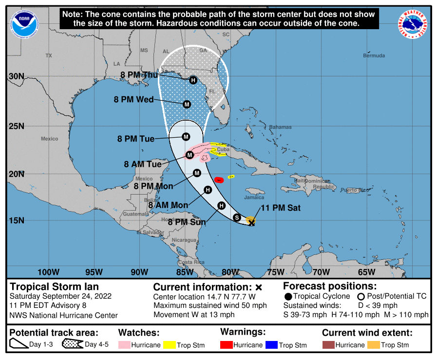
As of 11 pm, the National Hurricane Center forecast shows that they expect Ian to become a hurricane by early Monday morning and a major hurricane by early Tuesday. It may stay at that strength until Thursday shortly before it makes landfall. Most of Florida except the southeast area around Miami is currently in the 5-day forecast cone, and all of southern Georgia and the southeast corner of Alabama are also in that cone now. Of course we know that impacts will spread far outside the cone, and 2-4 inches of rain are expected to fall in southern Florida by Tuesday morning, with up to 6 inches expected in the Keys. The rain will be moving north with the center of Ian, most likely in waves in the spiral bands around the storm. Tropical storm force winds could arrive in southern Florida as early as Tuesday morning but it will likely be later that day before the winds get that strong. Those storm winds could arrive at the northern Gulf Coast as early as Wednesday morning but are more likely to get there Wednesday evening about 12 hours later.
Rainfall will continue to move north ahead of the storm and several inches could fall in southern, central and perhaps even northern Georgia and Alabama near and to the right of the storm’s track. There may also be some isolated small tornadoes in the spiral bands. Tropical force winds could occur in northern GA and AL by Wednesday night but are more likely during the day on Thursday, at least under the current forecast path. With wet conditions from the storm, you can expect trees to fall on power lines, buildings, and vehicles, so be prepared to be without power for a few days if you are near the path of the storm. Coastal areas along both the western and eastern sides of the Florida peninsula and later, Georgia and South Carolina, may be affected by the winds of Ian, and those areas can expect to see high water levels and waves, especially during periods of high tide, some flooded roads at low elevations, and a strong storm surge in the region near and to the right of where Ian makes landfall, wherever that ends up being.
I know this is an especially anxious time of the year for farmers since many crops like cotton, pecans, and peanuts are near or at harvest. It is clear that the wind and rain are going to do some potentially significant damage to crops in the area near Ian’s path. I am not a plant scientist so I can’t give you much useful information about what to do about the timing of harvesting crops, but your local extension agents can provide more help with that. They will help you to consider the current maturity of the crop, whether it makes sense to harvest before the storm (assuming you have the equipment and the labor, a place to store the crop, and field conditions that allow you to do it), and what the economic costs will be. If you are worried about losses, be sure to take some pictures of your fields to have documentation for “before” to use in insurance claims.
Please keep abreast of NHC official forecasts, as they are likely to change as Ian continues to develop and move over very warm water. National Weather Service local forecasts can help you determine the timing of when winds will become strong and when rain will begin. In the meantime, you can prepare by making sure you have full gas tanks for your vehicles and generators (and know how to operate generators properly and make sure they work ahead of the storm), water and food for yourselves and livestock, and methods to communicate with other family members and colleagues if internet and power (and sometimes cell networks) go down.
I will post another update tomorrow night at the same time once the 11 pm forecast maps are issued. You can get intermediate updates at https://www.nhc.noaa.gov/ or from many media sources.