If you live in the western part of our region, you have no doubt already experienced a very rainy Saturday. Fortunately for us in Athens GA it held off long enough to avoid raining on the outdoor graduation ceremony that was held in Sanford Stadium last night. Some other colleges and universities that had similar festivities planned for this weekend may not have been so lucky.
The rain has not been continuous for most of us but has come in waves as bands of storms move around the broad center of a low pressure center that is cut off from the main circulation of the atmosphere. This “cut-off low” is drifting ever so slowly off to the east and eventually to the northeast since it is not being pushed around by the jet stream. It is going to be over the Southeast through Wednesday, and since there is rising air and a lot of moisture in this low, that means abundant storms and rainfall, especially during the day when heating from the sun helps the air rise more strongly and also evaporates water from the rain-soaked ground, adding to the humidity. That could also mean isolated areas of severe weather embedded in the flow, so you will need to keep an eye out for any storms that do occur near you.
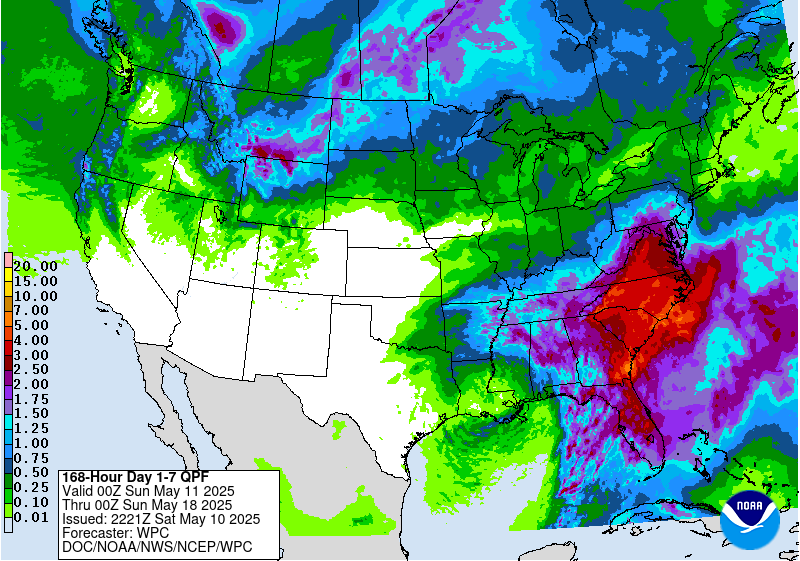
As of Saturday night, the center of the low is still well to the west of us here in GA, which means that we are getting winds from the south off of the Gulf, bringing more moisture into the region. If the storm gets stronger and its central pressure lower, we could see an atmospheric river pouring an immense amount of moisture into the region before it moves away. The location of the heaviest rain will drift to the east and northeast ahead of the central low pressure, so the heaviest rain today has been in Alabama and Georgia. But it will shift over the next few days as the circulation around the low also moves, and by Monday the heaviest rain will be in eastern Georgia, the Florida Peninsula, the Carolinas, and western Virginia, although there could still be showery weather as far west as Arkansas and Louisiana. More of the moisture flowing into the storm will be coming from the Atlantic, although Gulf flow will also continue. By Tuesday morning, the heaviest rain should be in eastern NC and VA, although showers will continue as far west as NE Alabama. By Wednesday morning, the low should have been picked up by the mid-latitude circulation and will be moving out of the region. Keep in mind that it is very hard to predict the timing of the movement of a cut-off low because it is not connected to the main atmospheric circulation and so it is drifting with little outside influence. That makes it very hard to predict its movement over time. So don’t be surprised if it does not follow exactly this schedule.
The result of having the cut-off low over us is rounds and rounds of rainfall in bands circulating around the center of the low but especially in the areas where moisture is flowing into the region from the Gulf and Atlantic. That means it won’t be constant rain but it will be persistent for several days. Here in Athens, they expect our heaviest rain may fall on Monday and Monday night, with up to 2 inches possible. With the rainfall we have already received, the ground will not be able to absorb as much and there will be some local flooding. I guess that the recent drought that has been expanding in parts of the region will be a help since the ground is so dry that the first couple of inches will probably just soak in and not run off at all. Amounts over all could reach several inches over a lot of the area with parts of western SC and NC receiving up to 5 inches due to the mountains.
After the low moves off towards the end of the week, most of the region should see dry conditions for a few days, although the next rainstorm will be moving in from the northwest and will bring more rain to the northwestern parts of the region late in the week. Weeks 2 through 4 should see the likelihood of wetter than normal conditions continuing in the northern parts of our region but most of the rest of the region will revert to equal chances of near, above- and below-normal rainfall through the first week of June.