As we wave goodbye to the last winter storm that moved through our region yesterday and today, we are starting to look ahead to the next storm that is expected to form soon in the Gulf Coast and move towards us in the Southeast before curving up to the Mid-Atlantic. There is still a lot of uncertainty about where this storm will go, and because of that there is not much confidence is who is likely to see snow, freezing rain, sleet, or just a cold rain. Brad Panovich, NC television meteorologist, had a good description of the situation in a morning post on social media. You can read it at https://x.com/wxbrad/status/1876098125586129206. Since this morning, the models have started to converge a bit, leading to an increase in certainty about where the biggest impacts of the storm are most likely.
The National Weather Service Office in Peachtree City, GA, provided an assessment of the likelihood of snow and freezing rain in Georgia. I will quote it below. Most of it has also been covered on their social media pages like Facebook. If you are in other NWS offices’ coverage area, I am sure they are also providing similar graphics on their home pages and in their social media accounts. Note that these forecasts are expected to continue to change as newer observational data and model runs become available.
BOTTOM LINE UP FRONT / OVERVIEW: Wintry weather is possible in Georgia, Friday and Saturday, as the next storm system tracks through the Southeast. At this time our confidence in the timing of the threat is fairly high, while our confidence in the precipitation type is low. Snow, sleet, freezing rain, and rain may all be in play with this system, but small variations (of 1 or 2 degrees) in the forecast could dramatically affect the southward extent of any winter weather impacts. At this time the risk for hazardous wintry weather is highest along and north of Interstate 20, though some potential exists for impacts to extend southward into central Georgia. Expect additional updates from us in the coming days that should further refine the location of the line between frozen and unfrozen precipitation.
WHAT:
- Accumulations of snow, sleet or ice are possible in Georgia Friday and Saturday.
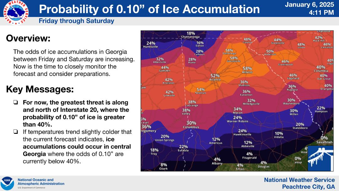
- At this time the threat for wintry weather is highest along and north of Interstate 20.
- Confidence in where the line between frozen and just liquid precipitation is going set up is low at this time — expect adjustments to the forecast in the coming days.
WHERE & WHEN:
- Friday and Saturday, with the highest potential for wintry accumulations sometime Friday into Friday night.
- Wintry weather is most likely along and north of Interstate 20, but some threat does extent into central Georgia.
IMPACTS:
- Hazardous travel conditions may develop, with the threat being highest in north Georgia.
- There is some potential for isolated power outages due to ice accumulations.
- Expect a very high level of interest and concern from the public, and be alert for the impact of potential gotcha forecasts via social media.
FORECAST CONFIDENCE:
- Moderate to High confidence in the timing, though the time window for wintry weather may narrow in later forecasts.
- Low confidence in the precipitation types.
- Low confidence in the southward extent of any wintry precipitation.
GRAPHICS:
Probability of 1″ of Snow Accumulation

Probability of 0.10″ of Ice Accumulation