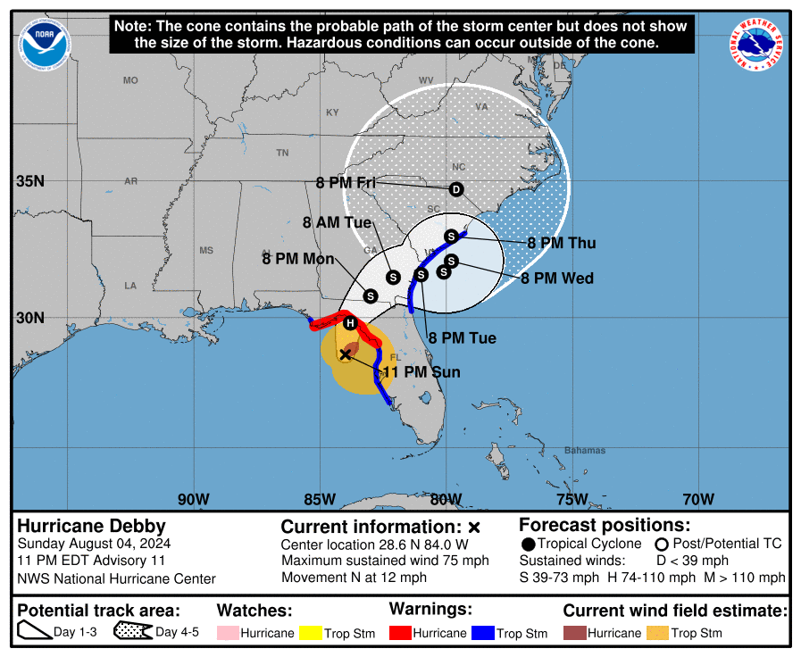
As of 11 pm on August 4, Debby was declared a hurricane with winds of 75 miles per hour. As expected, it has been getting stronger all day so this is no surprise, and further strengthening is likely before it makes landfall sometime on Monday along Florida’s Big Bend area. After it makes landfall it is expected to turn towards the northeast and slow down, crossing southeastern GA as it moves east. The winds will be slowly dying down as it moves through Georgia but they will be strong enough to do some significant damage, especially if the storm intensifies before it makes landfall. While the center of the forecast cone shows Debby as going offshore into the Atlantic, there are some model runs that keep it over land, so the exact path is still uncertain. And you can see by the ballooning of the end of the 5-day cone that Debby could end up almost anywhere. Some individual model runs even show it moving west again into western Georgia, although those are very few and it is unlikely that Debby would take that path. This large range of possibilities has been shown consistently by the forecast models so there is no surprise there, either.
The whole time it is moving, Debby will be raining, and since it will not be moving fast, the amount of rain it drops in any location is going to be significant. A large swath of SE Georgia could experience 12 inches of rain or more, with some areas expected to receive 16-20 inches. This is going to be the largest amount of rain many of these areas have ever experienced, and the consequences will be severe. Water supplies and power may be extremely limited for several days. After TS Alberto stalled over SW Georgia in 1994, some areas of Macon did not get water for 32 days according to one of my friends who lived there. Any kind of movement through the region is going to be hampered by eroded roads, downed power lines and trees, and flooded bridges, so it will be difficult to get supplies and repair equipment in. Since the rain has already started in southern GA, it is probably too late to do much more to prepare there, but it might be smart to fill up bathtubs with water just in case you lose your own supply. Folks in South Carolina have a little more time to get ready but don’t wait too long because the rain will be there soon.
Impacts from Debby on Sunday have included a lot of rain in western Florida as well as storm surge along the coast there. The storm surge will be worse near the point of landfall because the curve of the coast concentrates the water into a small area. There was a similar, but even larger, storm surge with Idalia last year. There have also been a number of tornadoes in the area northeast of the center, although most of them are relatively small and short-lived. Later in the week storm surge may also occur along the East Coast, especially if the center of Debby makes it off the coast and it intensifies again. This, combined with the rain and the river flooding that will occur, will swamp many areas along the immediate East Coast and could result in days with no power in the hottest time of year.
While the future path of Debby is very hard to predict at this point, we will keep watching for clues as to where it goes and what other impacts we might see. By the end of the week, the steering currents will pick up again and will likely usher the remains of Debby off to the northeast. Meanwhile, stay safe by not driving over water-covered roads, since that is the single biggest killer in flooded conditions. In TS Alberto in 1994, 32 people were directly killed by the storm in SW Georgia and the economic losses were over $1 billion in 1994 dollars. I expect the damage from Debby could be even greater because of the increases in infrastructure since 1994. After the storm is over, many of you will be called on to help assess the damages as well as start to recover from the disaster. Help your neighbors as you can because it will be hard for emergency personnel to reach everyone who needs assistance with the widespread damage I expect.
