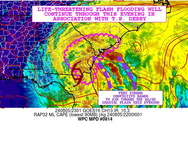
Since the forecasts for Debby have been quite good in timing and intensity as well as the path it has taken so far, I am not going to spend much time discussing them. Tonight and tomorrow Debby is expected to continue its slow movement northeast and will likely go over the coast into the Atlantic sometime during the day on Tuesday. While the paths diverge a little after that, in general the pattern of heavy rain is likely to continue for at least another day, mostly over South Carolina, before it makes another landfall on Thursday afternoon and starts to pick up speed as the steering currents kick in again. The area of heaviest rain is likely to be near Charleston, which has already experienced more rain than forecast today.
The graphic below tells the story for the next day.

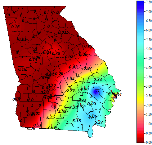
So far, parts of Georgia have received several inches of rain. Glennville, in the southeastern part of the state, has received 7.77 inches from Debby and it is still raining there, so the forecast for SE Georgia has been pretty accurate. Here is the rainfall map for just rain since the beginning of the day on the 5th until 10:34 pm. Note that there are a couple of clogged gauges with false zeros at Tifton and Ossabaw Island along the coast. The rain tonight is concentrated mostly in eastern Georgia and southern South Carolina and is moving slowly north and east over time. Streets are flooding in Savannah and they are also expecting a lot more rain overnight and into tomorrow.
Continue to monitor NWS forecasts and stay off of flooded roads to reduce the chance of drowning. Tomorrow we should expect Debby to continue its slow path to the northeast as it weakens and starts to decay due to the inflow of dry air into the circulation. If it does get over water, the storm could intensify a bit before it makes landfall again.
