I’ve been getting phone calls and emails asking when we can expect the El Nino rains to start to reduce the drought that has been growing across a lot of the Southeast in the past few weeks. Unfortunately, the Climate Prediction Center and the long-range models do not give much hope of needed relief in the near future. The CPC maps for November shown below indicate that there is a slight tendency towards warmer than normal conditions in southern parts of the Southeast in November, while most of the region is equally likely to experience near-, above-, or below-normal precipitation. The only areas that are showing a tendency in one direction or another are Florida and the coastal plains of Georgia and South Carolina, which are leaning towards wetter conditions, and northern Alabama and Georgia and the highlands of North Carolina and Virginia, which are leaning towards drier than normal conditions.
The long-range models that go out to mid-November do not show a switch to a wetter pattern through the middle of November and most parts of the region with the exception of Virginia are expected to receive only about half an inch of rain in the next two weeks. This will continue to hamper farmers trying to plant winter grains and forage because it is too dry for the seeds to germinate well. It will also mean that cattle producers will likely need to continue feeding supplemental hay for at least the next couple of weeks. There is often a pattern shift to a more winter-like weather pattern around the third week of November, but of course there are no guarantees. The longest-term climate forecasts continue to indicate the likelihood of a wetter than normal winter in southern AL and GA and in northern FL, but that is not guaranteed either, although it has a fairly high probability of happening.
Fortunately, the long-range models have also backed off on the idea of freezing weather next week, after the cold air we will feel Wednesday through Friday moves out of northern and more inland parts of the region. So areas in the coastal plains of Alabama, Georgia and the Carolinas may have a few more weeks of freeze-free weather before colder conditions return.
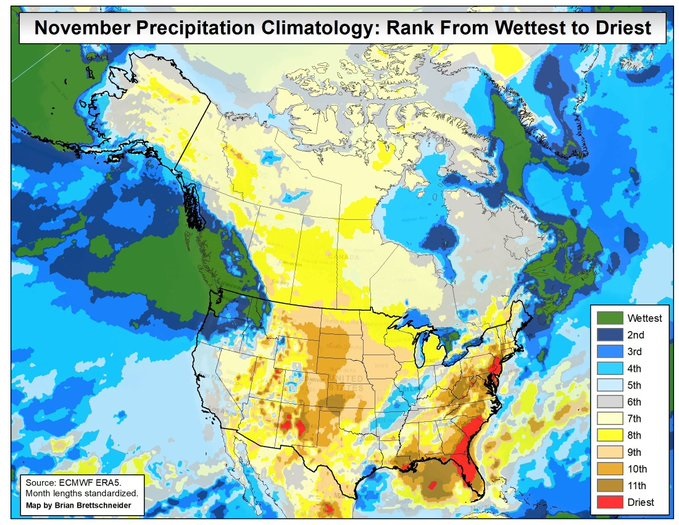
Also, note that for a lot of the Southeast, November is typically the driest month of the year, and so far it does not look like this year will be an exception. The final map is from @Climatologist49, Brian Brettschneider, who does amazing climate maps that you should really take a look at if you are still on Twitter (I refuse to call it X).