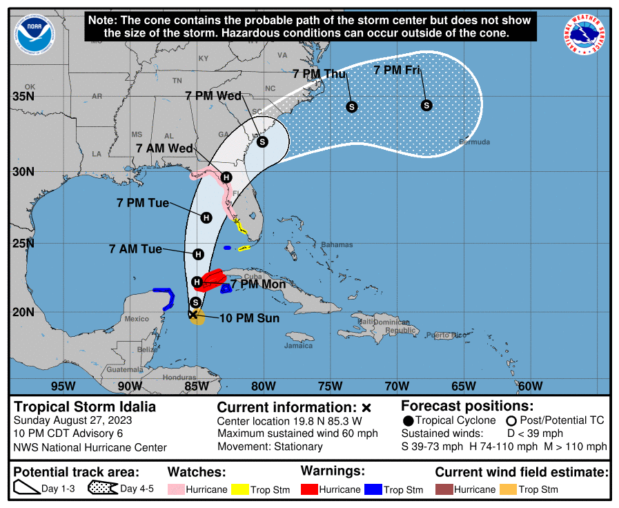
Early Sunday morning, Tropical Depression 10 became Tropical Storm Idalia. Today, the storm wobbled south and did not show much sign of organizing, but in the last couple of hours on Sunday that has started to change, and the circulation is starting to look more robust. This is a sign that the storm is likely starting to deepen and could become a hurricane sooner than predicted. This will allow better skill in forecasting the movement of the storm, since a well-defined vertical storm is easier for the mid-level winds to push around than the loose array of thunderstorms that was present most of today. The forecast cones that have been issued today by the National Hurricane Center have been shifting slightly towards the east, but that is no guarantee that that trend will continue once the storm becomes better organized.
Idalia is currently predicted to make landfall along the northeastern Gulf Coast early on Wednesday morning, likely as a category 2 storm. However, because of its drift today to the south, it could take longer to reach the Gulf Coast. A longer time over the very warm Gulf water would be likely to increase the strength of the storm, and rapid intensification similar to Hurricanes Ian and Michael cannot be ruled out, although it is not likely to become a Category 5 storm. If it is a strong storm at landfall, it could make it all the way into Georgia as a hurricane. A later landfall would give people more time to prepare, but the impacts would like be worse in this case.
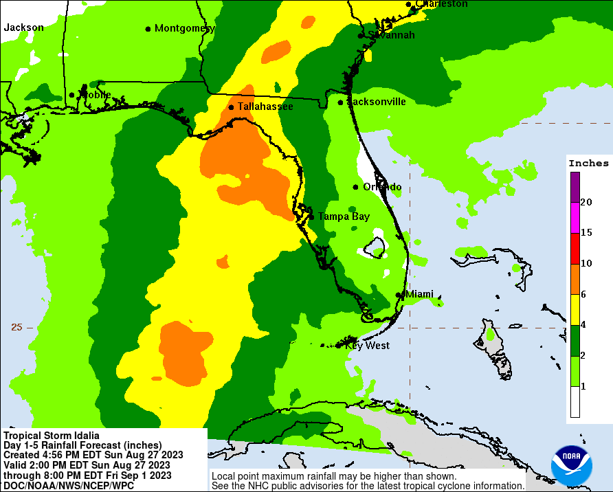
Since the storm has a broad circulation, we are likely to see strong winds and rain far from the center of the storm, so don’t focus just on the predicted storm path or cone. That only shows where the center of the storm will be and does not highlight everywhere strong winds and heavy rain will occur. The biggest impacts, including heavy rain of up to over 6 inches of rain, high winds, and some scattered tornadoes to the right of the storm track, will start occurring over the Florida peninsula on Tuesday and will spread into southern Georgia by late Tuesday night or early Wednesday morning, so preparations for the hurricane should be complete by Tuesday sunset in those areas. The storm is then expected to move northeast along the Georgia coast and then into South Carolina. Windy and rainy conditions could cover quite a bit of Georgia and South Carolina as well as southeast Alabama and eastern North Carolina.
There are currently storm surge warnings in the Big Bend area of the northeast Gulf of Mexico, where a shallow shelf will help water rise to 11 feet or more in some places. This could be made worse by extra-high tides due to the full moon later this week. On the East Coast, onshore wind ahead of Idalia will pile up 2-4 feet of water along the coast, but this could also increase if it hits at high tide. The runoff from the heavy rain will make the coastal flooding worse. If you have a boat along the coast, now would be a good time to secure it.
If you live in the area that Idalia is likely to impact, now is the time to get your preparations done. Bring in any loose items and remove dead tree limbs that could become wind-driven missiles. Gas up vehicles and move them out of areas likely to flood. Prepare for power outages and lack of water for several days. Determine if you need to evacuate and if you do, get out sooner rather than waiting until roads are clogged or flooded. Producers should consider putting fungicides on their peanuts and other crops before the storm hits since it may be too wet to get into the fields for several days after Idalia passes and fungal diseases are rampant this year. Pecan farmers should also stop irrigating their trees for a few days to let the soil dry out so that there is less likelihood of trees being blown over due to the wet ground. Livestock producers and pet owners should make sure their animals have a safe place to shelter and have food and water available for after the storm passes.
Most importantly, keep watching the forecast for updates in the timing and path of the storm, because where you are with respect to the storm’s circulation will help determine what weather you experience at your location. Listen to the National Weather Service for local forecasts and be prepared to leave if your Emergency Managers issue an evacuation order.